You are here: Home > Network List > IW - Intermountain West Stations List
> Station PLID Pearl Lake, Idaho, USA > Earthquake Result Viewer
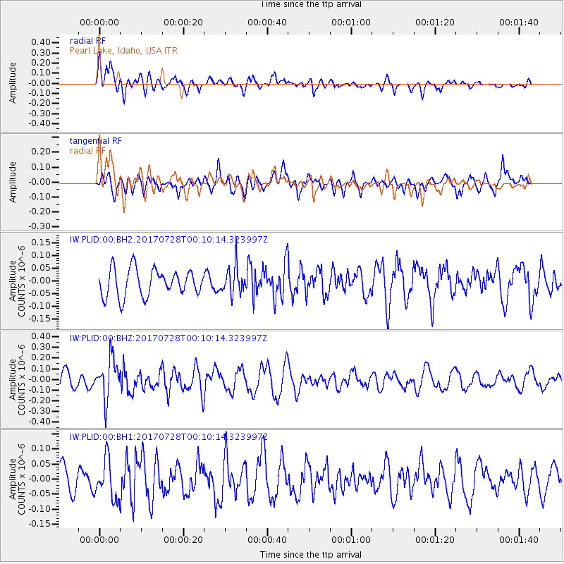
PLID Pearl Lake, Idaho, USA - Earthquake Result Viewer
*The percent match for this event was below the threshold and hence no stack was calculated.
| Earthquake location: |
Southeast Of Honshu, Japan |
| Earthquake latitude/longitude: |
29.3/143.0 |
| Earthquake time(UTC): |
2017/07/27 (208) 23:58:52 GMT |
| Earthquake Depth: |
10 km |
| Earthquake Magnitude: |
5.3 Mww |
| Earthquake Catalog/Contributor: |
NEIC PDE/us |
|
| Network: |
IW Intermountain West |
| Station: |
PLID Pearl Lake, Idaho, USA |
| Lat/Lon: |
45.09 N/116.00 W |
| Elevation: |
2164 m |
|
| Distance: |
77.0 deg |
| Az: |
45.525 deg |
| Baz: |
298.357 deg |
| Ray Param: |
$rayparam |
*The percent match for this event was below the threshold and hence was not used in the summary stack. |
|
| Radial Match: |
47.573376 % |
| Radial Bump: |
400 |
| Transverse Match: |
53.102093 % |
| Transverse Bump: |
400 |
| SOD ConfigId: |
2140511 |
| Insert Time: |
2017-08-10 15:58:53.247 +0000 |
| GWidth: |
2.5 |
| Max Bumps: |
400 |
| Tol: |
0.001 |
|
Signal To Noise
| Channel | StoN | STA | LTA |
| IW:PLID:00:BHZ:20170728T00:10:14.323997Z | 2.6295655 | 1.8986162E-7 | 7.220266E-8 |
| IW:PLID:00:BH1:20170728T00:10:14.323997Z | 1.8160185 | 6.751484E-8 | 3.7177397E-8 |
| IW:PLID:00:BH2:20170728T00:10:14.323997Z | 1.0457934 | 5.6268696E-8 | 5.3804794E-8 |
| Arrivals |
| Ps | |
| PpPs | |
| PsPs/PpSs | |


