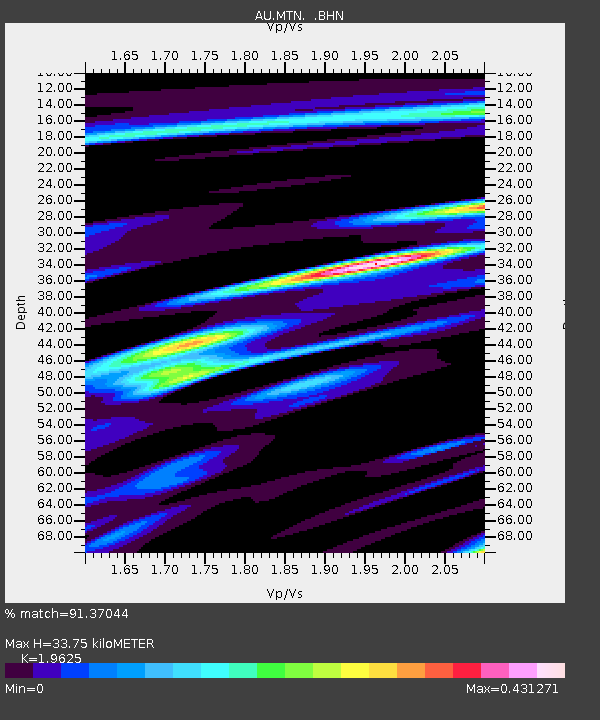
MTN Manton Dam, Northern Territory - Earthquake Result Viewer

Earthquake location: Fox Islands, Aleutian Islands
Earthquake latitude/longitude: 52.6/-167.1
Earthquake time(UTC): 2009/10/13 (286) 20:21:53 GMT
Earthquake Depth: 14 km
Earthquake Magnitude: 5.9 MB, 6.4 MS, 6.4 MW, 6.4 MW
Earthquake Catalog/Contributor: WHDF/NEIC
Network: AU Australian Seismological Centre
Station: MTN Manton Dam, Northern Territory
Lat/Lon: 12.84 S/131.13 E
Elevation: 137 m
Distance: 83.9 deg
Az: 239.774 deg
Baz: 32.705 deg
Ray Param: 0.04586211
Estimated Moho Depth: 33.75 km
Estimated Crust Vp/Vs: 1.96
Assumed Crust Vp: 6.61 km/s
Estimated Crust Vs: 3.368 km/s
Estimated Crust Poisson's Ratio: 0.32
Radial Match: 91.37044 %
Radial Bump: 400
Transverse Match: 73.058784 %
Transverse Bump: 400
SOD ConfigId: 2622
Insert Time: 2010-03-09 00:16:52.237 +0000
GWidth: 2.5
Max Bumps: 400
Tol: 0.001

Signal To Noise

ChannelStoNSTALTA
AU:MTN: :BHN:20091013T20:33:50.918994Z2.626224.22071E-71.6071425E-7
AU:MTN: :BHE:20091013T20:33:50.918994Z1.61508611.7407814E-71.07782576E-7
AU:MTN: :BHZ:20091013T20:33:50.918994Z1.07218581.3311312E-71.2415117E-7
Arrivals
Ps5.0 SECOND
PpPs15 SECOND
PsPs/PpSs20 SECOND