You are here: Home > Network List > US - United States National Seismic Network Stations List
> Station MNTX Cornudas Mountains, Texas, USA > Earthquake Result Viewer
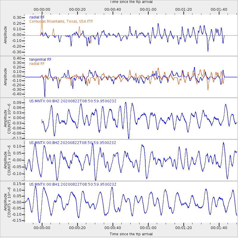
MNTX Cornudas Mountains, Texas, USA - Earthquake Result Viewer
*The percent match for this event was below the threshold and hence no stack was calculated.
| Earthquake location: |
Ascension Island Region |
| Earthquake latitude/longitude: |
-7.1/-12.7 |
| Earthquake time(UTC): |
2020/08/22 (235) 08:38:04 GMT |
| Earthquake Depth: |
10 km |
| Earthquake Magnitude: |
5.9 Mww |
| Earthquake Catalog/Contributor: |
NEIC PDE/us |
|
| Network: |
US United States National Seismic Network |
| Station: |
MNTX Cornudas Mountains, Texas, USA |
| Lat/Lon: |
31.70 N/105.38 W |
| Elevation: |
404 m |
|
| Distance: |
96.0 deg |
| Az: |
301.12 deg |
| Baz: |
94.627 deg |
| Ray Param: |
$rayparam |
*The percent match for this event was below the threshold and hence was not used in the summary stack. |
|
| Radial Match: |
48.1798 % |
| Radial Bump: |
400 |
| Transverse Match: |
65.33215 % |
| Transverse Bump: |
400 |
| SOD ConfigId: |
21709731 |
| Insert Time: |
2020-09-05 08:50:39.821 +0000 |
| GWidth: |
2.5 |
| Max Bumps: |
400 |
| Tol: |
0.001 |
|
Signal To Noise
| Channel | StoN | STA | LTA |
| US:MNTX:00:BHZ:20200822T08:50:59.950023Z | 1.5269477 | 7.0752776E-8 | 4.633608E-8 |
| US:MNTX:00:BH1:20200822T08:50:59.950023Z | 1.8086752 | 8.43325E-8 | 4.662667E-8 |
| US:MNTX:00:BH2:20200822T08:50:59.950023Z | 1.2570419 | 5.1548614E-8 | 4.1007873E-8 |
| Arrivals |
| Ps | |
| PpPs | |
| PsPs/PpSs | |


