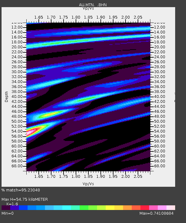
MTN Manton Dam, Northern Territory - Earthquake Result Viewer

Earthquake location: Southeast Of Loyalty Islands
Earthquake latitude/longitude: -22.6/170.9
Earthquake time(UTC): 2009/01/19 (019) 03:35:18 GMT
Earthquake Depth: 12 km
Earthquake Magnitude: 5.7 MB, 6.4 MS, 6.5 MW, 6.5 MW
Earthquake Catalog/Contributor: WHDF/NEIC
Network: AU Australian Seismological Centre
Station: MTN Manton Dam, Northern Territory
Lat/Lon: 12.84 S/131.13 E
Elevation: 137 m
Distance: 39.0 deg
Az: 277.507 deg
Baz: 110.044 deg
Ray Param: 0.07522833
Estimated Moho Depth: 54.75 km
Estimated Crust Vp/Vs: 1.60
Assumed Crust Vp: 6.61 km/s
Estimated Crust Vs: 4.131 km/s
Estimated Crust Poisson's Ratio: 0.18
Radial Match: 95.23048 %
Radial Bump: 400
Transverse Match: 66.367874 %
Transverse Bump: 400
SOD ConfigId: 2658
Insert Time: 2010-03-09 00:17:28.991 +0000
GWidth: 2.5
Max Bumps: 400
Tol: 0.001

Signal To Noise

ChannelStoNSTALTA
AU:MTN: :BHN:20090119T03:42:14.220005Z11.851181.8500051E-61.5610303E-7
AU:MTN: :BHE:20090119T03:42:14.220005Z3.23336773.7886917E-71.1717479E-7
AU:MTN: :BHZ:20090119T03:42:14.220005Z9.0875471.1603029E-61.2768054E-7
Arrivals
Ps5.4 SECOND
PpPs20 SECOND
PsPs/PpSs25 SECOND