You are here: Home > Network List > ZW13 - Locating North Texas Earthquakes Stations List
> Station IFDF Dallas Firestation > Earthquake Result Viewer
IFDF Dallas Firestation - Earthquake Result Viewer
| Earthquake location: |
Southern East Pacific Rise |
| Earthquake latitude/longitude: |
-49.8/-115.6 |
| Earthquake time(UTC): |
2020/08/22 (235) 11:58:48 GMT |
| Earthquake Depth: |
10 km |
| Earthquake Magnitude: |
5.6 Mww |
| Earthquake Catalog/Contributor: |
NEIC PDE/us |
|
| Network: |
ZW Locating North Texas Earthquakes |
| Station: |
IFDF Dallas Firestation |
| Lat/Lon: |
32.78 N/96.90 W |
| Elevation: |
130 m |
|
| Distance: |
83.9 deg |
| Az: |
15.785 deg |
| Baz: |
192.084 deg |
| Ray Param: |
0.045892358 |
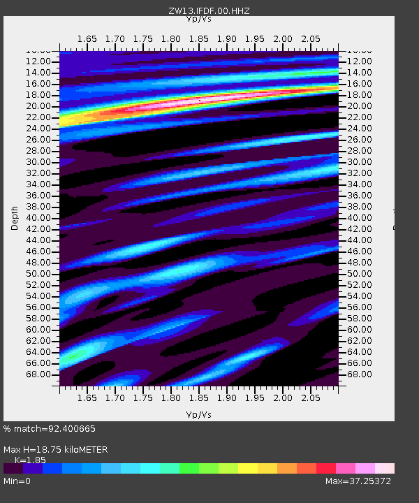
| Estimated Moho Depth: |
18.75 km |
| Estimated Crust Vp/Vs: |
1.85 |
| Assumed Crust Vp: |
6.38 km/s |
| Estimated Crust Vs: |
3.449 km/s |
| Estimated Crust Poisson's Ratio: |
0.29 |
|
| Radial Match: |
92.400665 % |
| Radial Bump: |
280 |
| Transverse Match: |
53.878296 % |
| Transverse Bump: |
242 |
| SOD ConfigId: |
21709731 |
| Insert Time: |
2020-09-05 12:13:22.741 +0000 |
| GWidth: |
2.5 |
| Max Bumps: |
400 |
| Tol: |
0.001 |
|

Signal To Noise
| Channel | StoN | STA | LTA |
| ZW:IFDF:00:HHZ:20200822T12:10:46.860003Z | 0.47942287 | 8.495067E-7 | 1.7719361E-6 |
| ZW:IFDF:00:HH1:20200822T12:10:46.860003Z | 0.47946265 | 1.1850137E-5 | 2.4715453E-5 |
| ZW:IFDF:00:HH2:20200822T12:10:46.860003Z | 0.8985979 | 1.0250655E-5 | 1.1407388E-5 |
| Arrivals |
| Ps | 2.6 SECOND |
| PpPs | 8.2 SECOND |
| PsPs/PpSs | 11 SECOND |


