You are here: Home > Network List > US - United States National Seismic Network Stations List
> Station MNTX Cornudas Mountains, Texas, USA > Earthquake Result Viewer
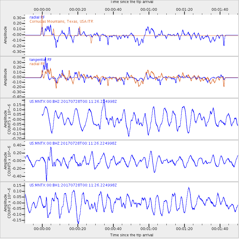
MNTX Cornudas Mountains, Texas, USA - Earthquake Result Viewer
*The percent match for this event was below the threshold and hence no stack was calculated.
| Earthquake location: |
Southeast Of Honshu, Japan |
| Earthquake latitude/longitude: |
29.3/143.0 |
| Earthquake time(UTC): |
2017/07/27 (208) 23:58:52 GMT |
| Earthquake Depth: |
10 km |
| Earthquake Magnitude: |
5.3 Mww |
| Earthquake Catalog/Contributor: |
NEIC PDE/us |
|
| Network: |
US United States National Seismic Network |
| Station: |
MNTX Cornudas Mountains, Texas, USA |
| Lat/Lon: |
31.70 N/105.38 W |
| Elevation: |
404 m |
|
| Distance: |
91.2 deg |
| Az: |
52.407 deg |
| Baz: |
305.696 deg |
| Ray Param: |
$rayparam |
*The percent match for this event was below the threshold and hence was not used in the summary stack. |
|
| Radial Match: |
50.73901 % |
| Radial Bump: |
400 |
| Transverse Match: |
66.7976 % |
| Transverse Bump: |
378 |
| SOD ConfigId: |
2140511 |
| Insert Time: |
2017-08-10 16:00:25.709 +0000 |
| GWidth: |
2.5 |
| Max Bumps: |
400 |
| Tol: |
0.001 |
|
Signal To Noise
| Channel | StoN | STA | LTA |
| US:MNTX:00:BHZ:20170728T00:11:26.224998Z | 2.2797334 | 1.8044635E-7 | 7.9152386E-8 |
| US:MNTX:00:BH1:20170728T00:11:26.224998Z | 1.0992962 | 6.9843566E-8 | 6.35348E-8 |
| US:MNTX:00:BH2:20170728T00:11:26.224998Z | 1.2753688 | 8.9274536E-8 | 6.9999E-8 |
| Arrivals |
| Ps | |
| PpPs | |
| PsPs/PpSs | |


