You are here: Home > Network List > TA - USArray Transportable Network (new EarthScope stations) Stations List
> Station M16K Timber Creek, AK, USA > Earthquake Result Viewer
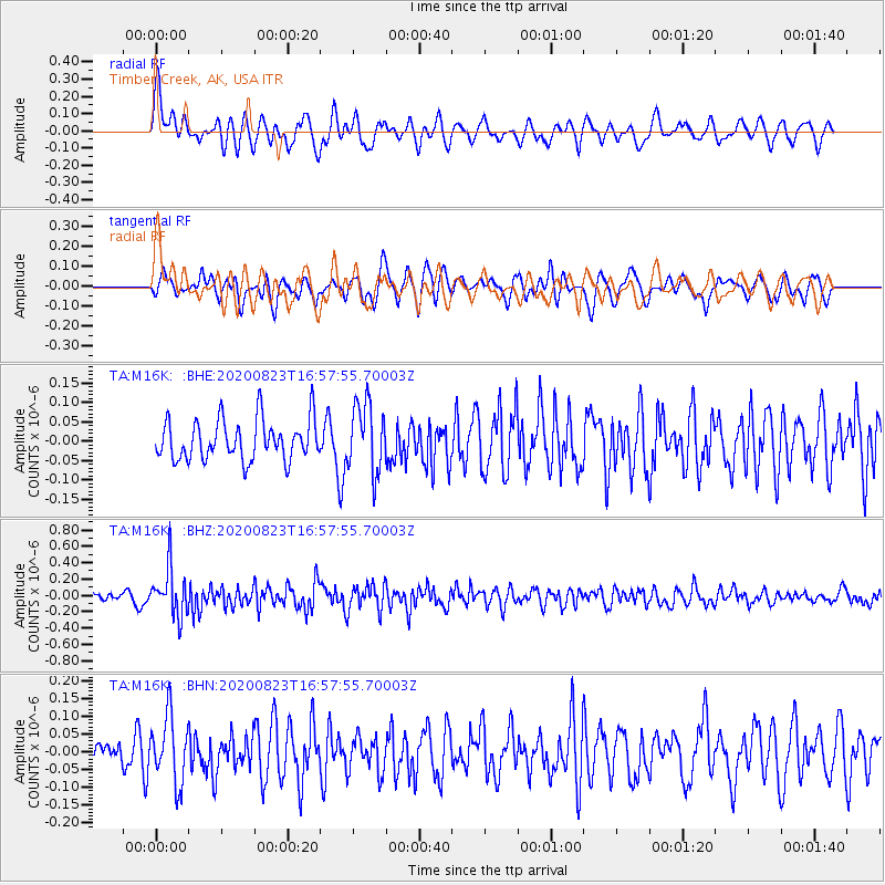
M16K Timber Creek, AK, USA - Earthquake Result Viewer
*The percent match for this event was below the threshold and hence no stack was calculated.
| Earthquake location: |
New Britain Region, P.N.G. |
| Earthquake latitude/longitude: |
-4.8/152.7 |
| Earthquake time(UTC): |
2020/08/23 (236) 16:46:47 GMT |
| Earthquake Depth: |
50 km |
| Earthquake Magnitude: |
5.5 Mww |
| Earthquake Catalog/Contributor: |
NEIC PDE/us |
|
| Network: |
TA USArray Transportable Network (new EarthScope stations) |
| Station: |
M16K Timber Creek, AK, USA |
| Lat/Lon: |
61.02 N/158.96 W |
| Elevation: |
394 m |
|
| Distance: |
75.5 deg |
| Az: |
22.076 deg |
| Baz: |
230.277 deg |
| Ray Param: |
$rayparam |
*The percent match for this event was below the threshold and hence was not used in the summary stack. |
|
| Radial Match: |
58.46995 % |
| Radial Bump: |
400 |
| Transverse Match: |
67.86325 % |
| Transverse Bump: |
400 |
| SOD ConfigId: |
21709731 |
| Insert Time: |
2020-09-06 17:01:52.709 +0000 |
| GWidth: |
2.5 |
| Max Bumps: |
400 |
| Tol: |
0.001 |
|
Signal To Noise
| Channel | StoN | STA | LTA |
| TA:M16K: :BHZ:20200823T16:57:55.70003Z | 4.334474 | 2.9272724E-7 | 6.753466E-8 |
| TA:M16K: :BHN:20200823T16:57:55.70003Z | 2.315524 | 9.2933114E-8 | 4.0134807E-8 |
| TA:M16K: :BHE:20200823T16:57:55.70003Z | 1.7062615 | 8.9076266E-8 | 5.2205518E-8 |
| Arrivals |
| Ps | |
| PpPs | |
| PsPs/PpSs | |


