You are here: Home > Network List > TA - USArray Transportable Network (new EarthScope stations) Stations List
> Station M31M Drury Creek, Yukon, CA > Earthquake Result Viewer
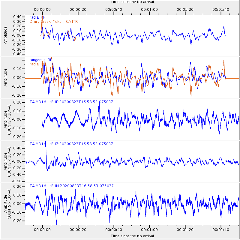
M31M Drury Creek, Yukon, CA - Earthquake Result Viewer
*The percent match for this event was below the threshold and hence no stack was calculated.
| Earthquake location: |
New Britain Region, P.N.G. |
| Earthquake latitude/longitude: |
-4.8/152.7 |
| Earthquake time(UTC): |
2020/08/23 (236) 16:46:47 GMT |
| Earthquake Depth: |
50 km |
| Earthquake Magnitude: |
5.5 Mww |
| Earthquake Catalog/Contributor: |
NEIC PDE/us |
|
| Network: |
TA USArray Transportable Network (new EarthScope stations) |
| Station: |
M31M Drury Creek, Yukon, CA |
| Lat/Lon: |
62.20 N/134.39 W |
| Elevation: |
639 m |
|
| Distance: |
86.3 deg |
| Az: |
26.683 deg |
| Baz: |
252.666 deg |
| Ray Param: |
$rayparam |
*The percent match for this event was below the threshold and hence was not used in the summary stack. |
|
| Radial Match: |
58.272175 % |
| Radial Bump: |
400 |
| Transverse Match: |
66.29964 % |
| Transverse Bump: |
400 |
| SOD ConfigId: |
21709731 |
| Insert Time: |
2020-09-06 17:01:58.912 +0000 |
| GWidth: |
2.5 |
| Max Bumps: |
400 |
| Tol: |
0.001 |
|
Signal To Noise
| Channel | StoN | STA | LTA |
| TA:M31M: :BHZ:20200823T16:58:53.07503Z | 5.2873025 | 1.9413775E-7 | 3.6717733E-8 |
| TA:M31M: :BHN:20200823T16:58:53.07503Z | 1.7126635 | 7.334039E-8 | 4.2822414E-8 |
| TA:M31M: :BHE:20200823T16:58:53.07503Z | 1.6574634 | 7.658452E-8 | 4.620586E-8 |
| Arrivals |
| Ps | |
| PpPs | |
| PsPs/PpSs | |


