You are here: Home > Network List > AV - Alaska Volcano Observatory Stations List
> Station TAPA Point Aries, Tanaga Volcano, Alaska > Earthquake Result Viewer
TAPA Point Aries, Tanaga Volcano, Alaska - Earthquake Result Viewer
| Earthquake location: |
Kermadec Islands Region |
| Earthquake latitude/longitude: |
-28.9/-176.3 |
| Earthquake time(UTC): |
2020/08/24 (237) 00:45:08 GMT |
| Earthquake Depth: |
10 km |
| Earthquake Magnitude: |
5.4 Mww |
| Earthquake Catalog/Contributor: |
NEIC PDE/us |
|
| Network: |
AV Alaska Volcano Observatory |
| Station: |
TAPA Point Aries, Tanaga Volcano, Alaska |
| Lat/Lon: |
51.81 N/177.81 W |
| Elevation: |
640 m |
|
| Distance: |
80.4 deg |
| Az: |
359.038 deg |
| Baz: |
178.641 deg |
| Ray Param: |
0.04831042 |
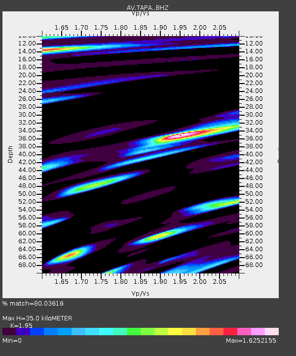
| Estimated Moho Depth: |
35.0 km |
| Estimated Crust Vp/Vs: |
1.95 |
| Assumed Crust Vp: |
5.88 km/s |
| Estimated Crust Vs: |
3.016 km/s |
| Estimated Crust Poisson's Ratio: |
0.32 |
|
| Radial Match: |
80.03616 % |
| Radial Bump: |
400 |
| Transverse Match: |
91.15773 % |
| Transverse Bump: |
246 |
| SOD ConfigId: |
21709731 |
| Insert Time: |
2020-09-07 00:48:42.154 +0000 |
| GWidth: |
2.5 |
| Max Bumps: |
400 |
| Tol: |
0.001 |
|
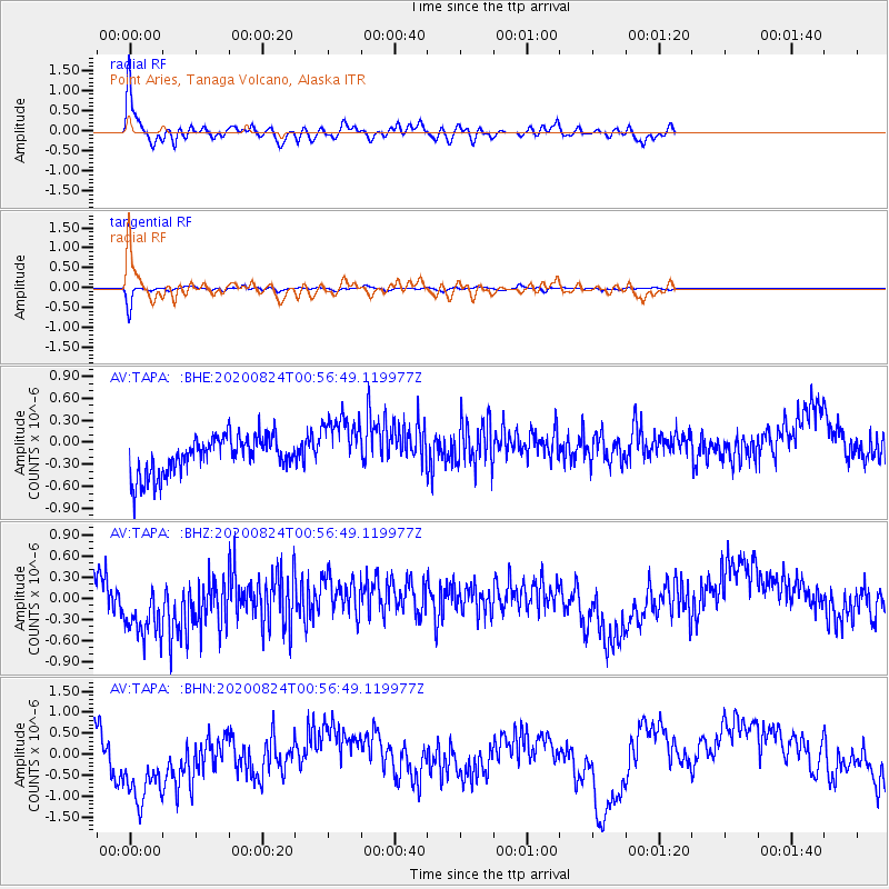
Signal To Noise
| Channel | StoN | STA | LTA |
| AV:TAPA: :BHZ:20200824T00:56:49.119977Z | 1.9972601 | 6.000533E-7 | 3.0043822E-7 |
| AV:TAPA: :BHN:20200824T00:56:49.119977Z | 1.9847765 | 1.1804385E-6 | 5.947463E-7 |
| AV:TAPA: :BHE:20200824T00:56:49.119977Z | 1.6636804 | 4.1317355E-7 | 2.483491E-7 |
| Arrivals |
| Ps | 5.8 SECOND |
| PpPs | 17 SECOND |
| PsPs/PpSs | 23 SECOND |


