You are here: Home > Network List > CI - Caltech Regional Seismic Network Stations List
> Station MPP McPhearson Peak > Earthquake Result Viewer
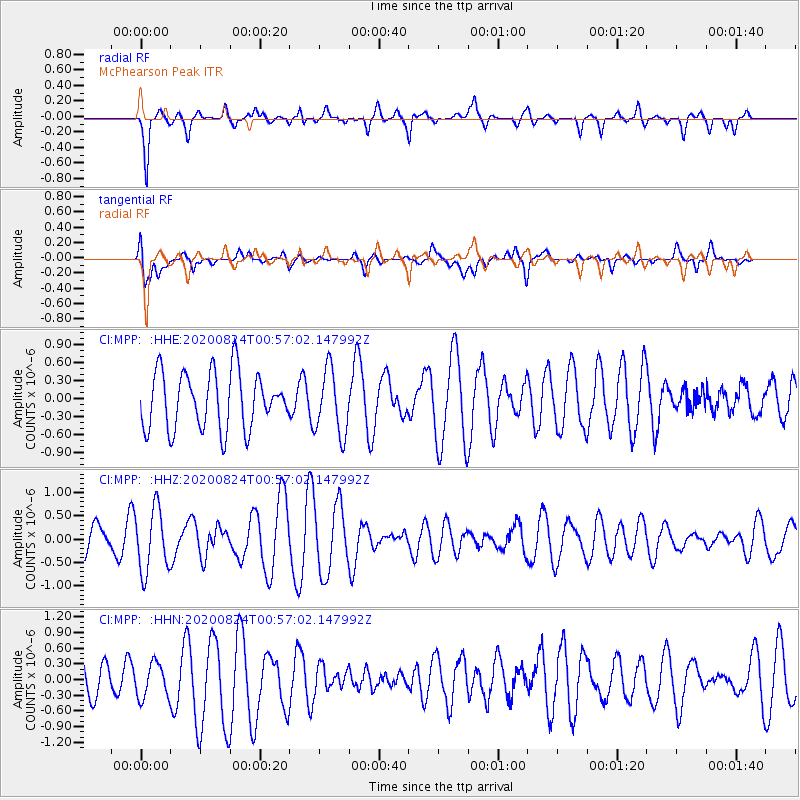
MPP McPhearson Peak - Earthquake Result Viewer
*The percent match for this event was below the threshold and hence no stack was calculated.
| Earthquake location: |
Kermadec Islands Region |
| Earthquake latitude/longitude: |
-28.9/-176.3 |
| Earthquake time(UTC): |
2020/08/24 (237) 00:45:08 GMT |
| Earthquake Depth: |
10 km |
| Earthquake Magnitude: |
5.4 Mww |
| Earthquake Catalog/Contributor: |
NEIC PDE/us |
|
| Network: |
CI Caltech Regional Seismic Network |
| Station: |
MPP McPhearson Peak |
| Lat/Lon: |
34.89 N/119.81 W |
| Elevation: |
1739 m |
|
| Distance: |
82.9 deg |
| Az: |
43.68 deg |
| Baz: |
227.436 deg |
| Ray Param: |
$rayparam |
*The percent match for this event was below the threshold and hence was not used in the summary stack. |
|
| Radial Match: |
68.18754 % |
| Radial Bump: |
348 |
| Transverse Match: |
39.68053 % |
| Transverse Bump: |
400 |
| SOD ConfigId: |
21709731 |
| Insert Time: |
2020-09-07 00:51:11.792 +0000 |
| GWidth: |
2.5 |
| Max Bumps: |
400 |
| Tol: |
0.001 |
|
Signal To Noise
| Channel | StoN | STA | LTA |
| CI:MPP: :HHZ:20200824T00:57:02.147992Z | 2.7293313 | 6.7884827E-7 | 2.487233E-7 |
| CI:MPP: :HHN:20200824T00:57:02.147992Z | 0.64954597 | 3.457004E-7 | 5.322185E-7 |
| CI:MPP: :HHE:20200824T00:57:02.147992Z | 1.1422863 | 5.3838306E-7 | 4.7132062E-7 |
| Arrivals |
| Ps | |
| PpPs | |
| PsPs/PpSs | |


