You are here: Home > Network List > CI - Caltech Regional Seismic Network Stations List
> Station MUR Murrieta > Earthquake Result Viewer
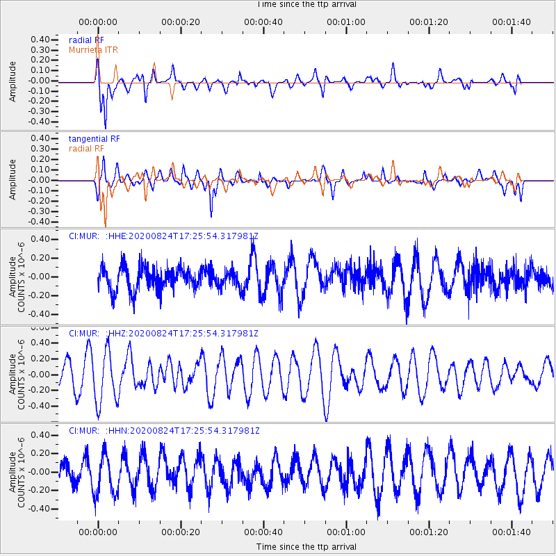
MUR Murrieta - Earthquake Result Viewer
*The percent match for this event was below the threshold and hence no stack was calculated.
| Earthquake location: |
Tonga Islands |
| Earthquake latitude/longitude: |
-15.4/-174.2 |
| Earthquake time(UTC): |
2020/08/24 (237) 17:14:55 GMT |
| Earthquake Depth: |
8.3 km |
| Earthquake Magnitude: |
5.6 Mww |
| Earthquake Catalog/Contributor: |
NEIC PDE/us |
|
| Network: |
CI Caltech Regional Seismic Network |
| Station: |
MUR Murrieta |
| Lat/Lon: |
33.60 N/117.20 W |
| Elevation: |
562 m |
|
| Distance: |
72.9 deg |
| Az: |
47.077 deg |
| Baz: |
237.823 deg |
| Ray Param: |
$rayparam |
*The percent match for this event was below the threshold and hence was not used in the summary stack. |
|
| Radial Match: |
78.9578 % |
| Radial Bump: |
400 |
| Transverse Match: |
74.7223 % |
| Transverse Bump: |
400 |
| SOD ConfigId: |
21709731 |
| Insert Time: |
2020-09-07 17:22:27.071 +0000 |
| GWidth: |
2.5 |
| Max Bumps: |
400 |
| Tol: |
0.001 |
|
Signal To Noise
| Channel | StoN | STA | LTA |
| CI:MUR: :HHZ:20200824T17:25:54.317981Z | 2.2740064 | 3.367499E-7 | 1.4808661E-7 |
| CI:MUR: :HHN:20200824T17:25:54.317981Z | 1.4479839 | 2.2423578E-7 | 1.548607E-7 |
| CI:MUR: :HHE:20200824T17:25:54.317981Z | 0.73817635 | 9.243821E-8 | 1.2522511E-7 |
| Arrivals |
| Ps | |
| PpPs | |
| PsPs/PpSs | |


