You are here: Home > Network List > IU - Global Seismograph Network (GSN - IRIS/USGS) Stations List
> Station SLBS Sierra la Laguna Baja California Sur, Mexico > Earthquake Result Viewer
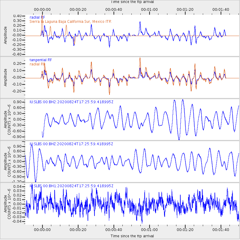
SLBS Sierra la Laguna Baja California Sur, Mexico - Earthquake Result Viewer
*The percent match for this event was below the threshold and hence no stack was calculated.
| Earthquake location: |
Tonga Islands |
| Earthquake latitude/longitude: |
-15.4/-174.2 |
| Earthquake time(UTC): |
2020/08/24 (237) 17:14:55 GMT |
| Earthquake Depth: |
8.3 km |
| Earthquake Magnitude: |
5.6 Mww |
| Earthquake Catalog/Contributor: |
NEIC PDE/us |
|
| Network: |
IU Global Seismograph Network (GSN - IRIS/USGS) |
| Station: |
SLBS Sierra la Laguna Baja California Sur, Mexico |
| Lat/Lon: |
23.69 N/109.94 W |
| Elevation: |
825 m |
|
| Distance: |
73.8 deg |
| Az: |
59.306 deg |
| Baz: |
244.81 deg |
| Ray Param: |
$rayparam |
*The percent match for this event was below the threshold and hence was not used in the summary stack. |
|
| Radial Match: |
48.727543 % |
| Radial Bump: |
400 |
| Transverse Match: |
48.877964 % |
| Transverse Bump: |
400 |
| SOD ConfigId: |
21709731 |
| Insert Time: |
2020-09-07 17:25:14.539 +0000 |
| GWidth: |
2.5 |
| Max Bumps: |
400 |
| Tol: |
0.001 |
|
Signal To Noise
| Channel | StoN | STA | LTA |
| IU:SLBS:00:BHZ:20200824T17:25:59.418995Z | 0.69975895 | 2.9508453E-7 | 4.2169458E-7 |
| IU:SLBS:00:BH1:20200824T17:25:59.418995Z | 0.8841427 | 1.4603012E-8 | 1.6516578E-8 |
| IU:SLBS:00:BH2:20200824T17:25:59.418995Z | 1.5978378 | 3.716914E-7 | 2.326215E-7 |
| Arrivals |
| Ps | |
| PpPs | |
| PsPs/PpSs | |


