You are here: Home > Network List > TA - USArray Transportable Network (new EarthScope stations) Stations List
> Station G19K Purcell Mountains, AK, USA > Earthquake Result Viewer
G19K Purcell Mountains, AK, USA - Earthquake Result Viewer
| Earthquake location: |
Tonga Islands |
| Earthquake latitude/longitude: |
-15.4/-174.2 |
| Earthquake time(UTC): |
2020/08/24 (237) 17:14:55 GMT |
| Earthquake Depth: |
8.3 km |
| Earthquake Magnitude: |
5.6 Mww |
| Earthquake Catalog/Contributor: |
NEIC PDE/us |
|
| Network: |
TA USArray Transportable Network (new EarthScope stations) |
| Station: |
G19K Purcell Mountains, AK, USA |
| Lat/Lon: |
66.14 N/157.09 W |
| Elevation: |
391 m |
|
| Distance: |
82.3 deg |
| Az: |
6.938 deg |
| Baz: |
196.649 deg |
| Ray Param: |
0.047010094 |
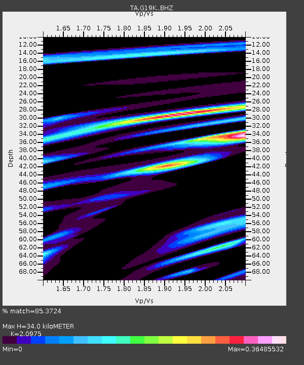
| Estimated Moho Depth: |
34.0 km |
| Estimated Crust Vp/Vs: |
2.10 |
| Assumed Crust Vp: |
6.577 km/s |
| Estimated Crust Vs: |
3.136 km/s |
| Estimated Crust Poisson's Ratio: |
0.35 |
|
| Radial Match: |
85.3724 % |
| Radial Bump: |
354 |
| Transverse Match: |
55.56971 % |
| Transverse Bump: |
400 |
| SOD ConfigId: |
21709731 |
| Insert Time: |
2020-09-07 17:30:10.893 +0000 |
| GWidth: |
2.5 |
| Max Bumps: |
400 |
| Tol: |
0.001 |
|

Signal To Noise
| Channel | StoN | STA | LTA |
| TA:G19K: :BHZ:20200824T17:26:46.275013Z | 1.9958702 | 1.0213889E-7 | 5.1175117E-8 |
| TA:G19K: :BHN:20200824T17:26:46.275013Z | 1.4024912 | 2.8099201E-8 | 2.0035205E-8 |
| TA:G19K: :BHE:20200824T17:26:46.275013Z | 1.4563222 | 3.3615947E-8 | 2.3082768E-8 |
| Arrivals |
| Ps | 5.8 SECOND |
| PpPs | 16 SECOND |
| PsPs/PpSs | 21 SECOND |


