You are here: Home > Network List > TA - USArray Transportable Network (new EarthScope stations) Stations List
> Station L15K Ungalak Mountain, AK, USA > Earthquake Result Viewer
L15K Ungalak Mountain, AK, USA - Earthquake Result Viewer
| Earthquake location: |
Tonga Islands |
| Earthquake latitude/longitude: |
-15.4/-174.2 |
| Earthquake time(UTC): |
2020/08/24 (237) 17:14:55 GMT |
| Earthquake Depth: |
8.3 km |
| Earthquake Magnitude: |
5.6 Mww |
| Earthquake Catalog/Contributor: |
NEIC PDE/us |
|
| Network: |
TA USArray Transportable Network (new EarthScope stations) |
| Station: |
L15K Ungalak Mountain, AK, USA |
| Lat/Lon: |
61.68 N/161.49 W |
| Elevation: |
219 m |
|
| Distance: |
77.4 deg |
| Az: |
6.173 deg |
| Baz: |
192.565 deg |
| Ray Param: |
0.050325718 |
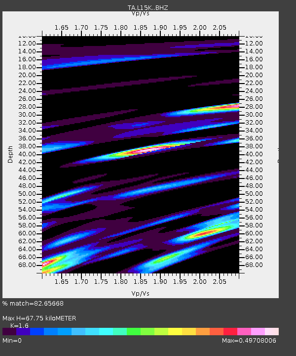
| Estimated Moho Depth: |
67.75 km |
| Estimated Crust Vp/Vs: |
1.60 |
| Assumed Crust Vp: |
6.182 km/s |
| Estimated Crust Vs: |
3.864 km/s |
| Estimated Crust Poisson's Ratio: |
0.18 |
|
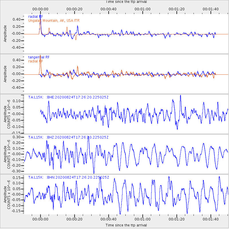
| Radial Match: |
82.65668 % |
| Radial Bump: |
400 |
| Transverse Match: |
65.58166 % |
| Transverse Bump: |
400 |
| SOD ConfigId: |
21709731 |
| Insert Time: |
2020-09-07 17:30:33.717 +0000 |
| GWidth: |
2.5 |
| Max Bumps: |
400 |
| Tol: |
0.001 |
|
Signal To Noise
| Channel | StoN | STA | LTA |
| TA:L15K: :BHZ:20200824T17:26:20.225025Z | 2.1301036 | 9.862851E-8 | 4.6302215E-8 |
| TA:L15K: :BHN:20200824T17:26:20.225025Z | 0.78366196 | 3.2459035E-8 | 4.141969E-8 |
| TA:L15K: :BHE:20200824T17:26:20.225025Z | 1.166327 | 3.1480624E-8 | 2.6991248E-8 |
| Arrivals |
| Ps | 6.8 SECOND |
| PpPs | 28 SECOND |
| PsPs/PpSs | 34 SECOND |


