You are here: Home > Network List > US - United States National Seismic Network Stations List
> Station EGMT Eagleton, Montana, USA > Earthquake Result Viewer
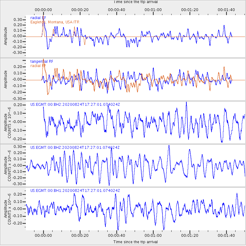
EGMT Eagleton, Montana, USA - Earthquake Result Viewer
*The percent match for this event was below the threshold and hence no stack was calculated.
| Earthquake location: |
Tonga Islands |
| Earthquake latitude/longitude: |
-15.4/-174.2 |
| Earthquake time(UTC): |
2020/08/24 (237) 17:14:55 GMT |
| Earthquake Depth: |
8.3 km |
| Earthquake Magnitude: |
5.6 Mww |
| Earthquake Catalog/Contributor: |
NEIC PDE/us |
|
| Network: |
US United States National Seismic Network |
| Station: |
EGMT Eagleton, Montana, USA |
| Lat/Lon: |
48.02 N/109.75 W |
| Elevation: |
1055 m |
|
| Distance: |
85.2 deg |
| Az: |
37.43 deg |
| Baz: |
240.864 deg |
| Ray Param: |
$rayparam |
*The percent match for this event was below the threshold and hence was not used in the summary stack. |
|
| Radial Match: |
53.06426 % |
| Radial Bump: |
400 |
| Transverse Match: |
45.54736 % |
| Transverse Bump: |
400 |
| SOD ConfigId: |
21709731 |
| Insert Time: |
2020-09-07 17:32:43.702 +0000 |
| GWidth: |
2.5 |
| Max Bumps: |
400 |
| Tol: |
0.001 |
|
Signal To Noise
| Channel | StoN | STA | LTA |
| US:EGMT:00:BHZ:20200824T17:27:01.074024Z | 1.1992015 | 7.354192E-8 | 6.132574E-8 |
| US:EGMT:00:BH1:20200824T17:27:01.074024Z | 0.829997 | 5.9281636E-8 | 7.142392E-8 |
| US:EGMT:00:BH2:20200824T17:27:01.074024Z | 1.1675707 | 7.771924E-8 | 6.6564915E-8 |
| Arrivals |
| Ps | |
| PpPs | |
| PsPs/PpSs | |


