You are here: Home > Network List > UW - Pacific Northwest Regional Seismic Network Stations List
> Station LEBA Lebam, WA, USA > Earthquake Result Viewer
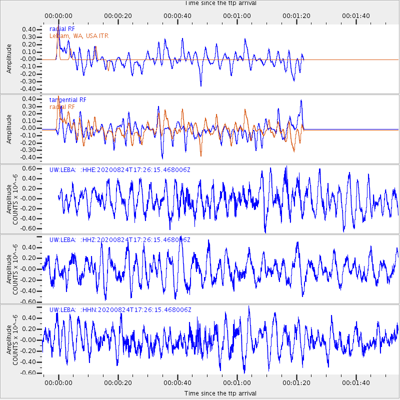
LEBA Lebam, WA, USA - Earthquake Result Viewer
*The percent match for this event was below the threshold and hence no stack was calculated.
| Earthquake location: |
Tonga Islands |
| Earthquake latitude/longitude: |
-15.4/-174.2 |
| Earthquake time(UTC): |
2020/08/24 (237) 17:14:55 GMT |
| Earthquake Depth: |
8.3 km |
| Earthquake Magnitude: |
5.6 Mww |
| Earthquake Catalog/Contributor: |
NEIC PDE/us |
|
| Network: |
UW Pacific Northwest Regional Seismic Network |
| Station: |
LEBA Lebam, WA, USA |
| Lat/Lon: |
46.55 N/123.56 W |
| Elevation: |
73 m |
|
| Distance: |
76.6 deg |
| Az: |
33.27 deg |
| Baz: |
230.065 deg |
| Ray Param: |
$rayparam |
*The percent match for this event was below the threshold and hence was not used in the summary stack. |
|
| Radial Match: |
55.18355 % |
| Radial Bump: |
400 |
| Transverse Match: |
49.352325 % |
| Transverse Bump: |
400 |
| SOD ConfigId: |
21709731 |
| Insert Time: |
2020-09-07 17:33:37.608 +0000 |
| GWidth: |
2.5 |
| Max Bumps: |
400 |
| Tol: |
0.001 |
|
Signal To Noise
| Channel | StoN | STA | LTA |
| UW:LEBA: :HHZ:20200824T17:26:15.468006Z | 1.1205803 | 1.6636011E-7 | 1.484589E-7 |
| UW:LEBA: :HHN:20200824T17:26:15.468006Z | 1.3921093 | 3.0610863E-7 | 2.1988836E-7 |
| UW:LEBA: :HHE:20200824T17:26:15.468006Z | 0.979326 | 1.851352E-7 | 1.8904349E-7 |
| Arrivals |
| Ps | |
| PpPs | |
| PsPs/PpSs | |


