You are here: Home > Network List > IU - Global Seismograph Network (GSN - IRIS/USGS) Stations List
> Station RSSD Black Hills, South Dakota, USA > Earthquake Result Viewer
RSSD Black Hills, South Dakota, USA - Earthquake Result Viewer
*The percent match for this event was below the threshold and hence no stack was calculated.
| Earthquake location: |
Komandorskiye Ostrova Region |
| Earthquake latitude/longitude: |
54.3/169.3 |
| Earthquake time(UTC): |
2017/07/28 (209) 02:39:16 GMT |
| Earthquake Depth: |
10 km |
| Earthquake Magnitude: |
5.5 mb |
| Earthquake Catalog/Contributor: |
NEIC PDE/us |
|
| Network: |
IU Global Seismograph Network (GSN - IRIS/USGS) |
| Station: |
RSSD Black Hills, South Dakota, USA |
| Lat/Lon: |
44.12 N/104.04 W |
| Elevation: |
2090 m |
|
| Distance: |
54.1 deg |
| Az: |
62.607 deg |
| Baz: |
313.778 deg |
| Ray Param: |
$rayparam |
*The percent match for this event was below the threshold and hence was not used in the summary stack. |
|
| Radial Match: |
71.535904 % |
| Radial Bump: |
400 |
| Transverse Match: |
73.29613 % |
| Transverse Bump: |
400 |
| SOD ConfigId: |
2140511 |
| Insert Time: |
2017-08-10 18:33:55.315 +0000 |
| GWidth: |
2.5 |
| Max Bumps: |
400 |
| Tol: |
0.001 |
|
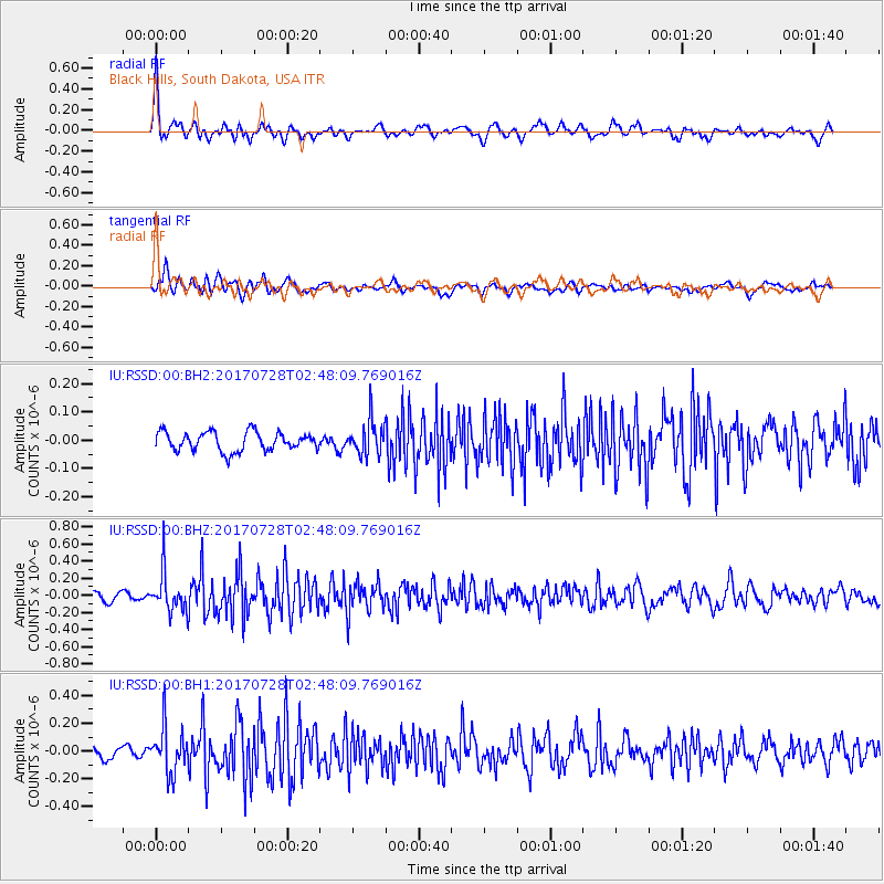
Signal To Noise
| Channel | StoN | STA | LTA |
| IU:RSSD:00:BHZ:20170728T02:48:09.769016Z | 4.3702416 | 2.2497098E-7 | 5.147793E-8 |
| IU:RSSD:00:BH1:20170728T02:48:09.769016Z | 3.8527162 | 1.6313867E-7 | 4.2343807E-8 |
| IU:RSSD:00:BH2:20170728T02:48:09.769016Z | 1.8679928 | 6.216598E-8 | 3.3279566E-8 |
| Arrivals |
| Ps | |
| PpPs | |
| PsPs/PpSs | |


