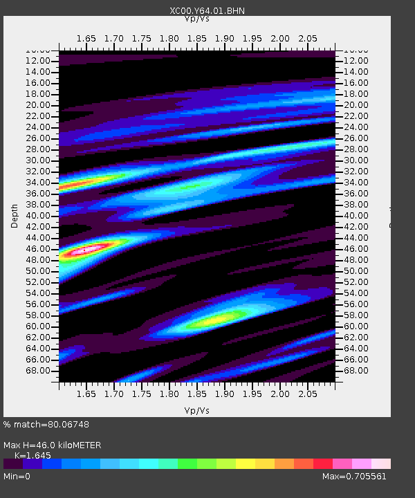
Y64 Y64 - Earthquake Result Viewer
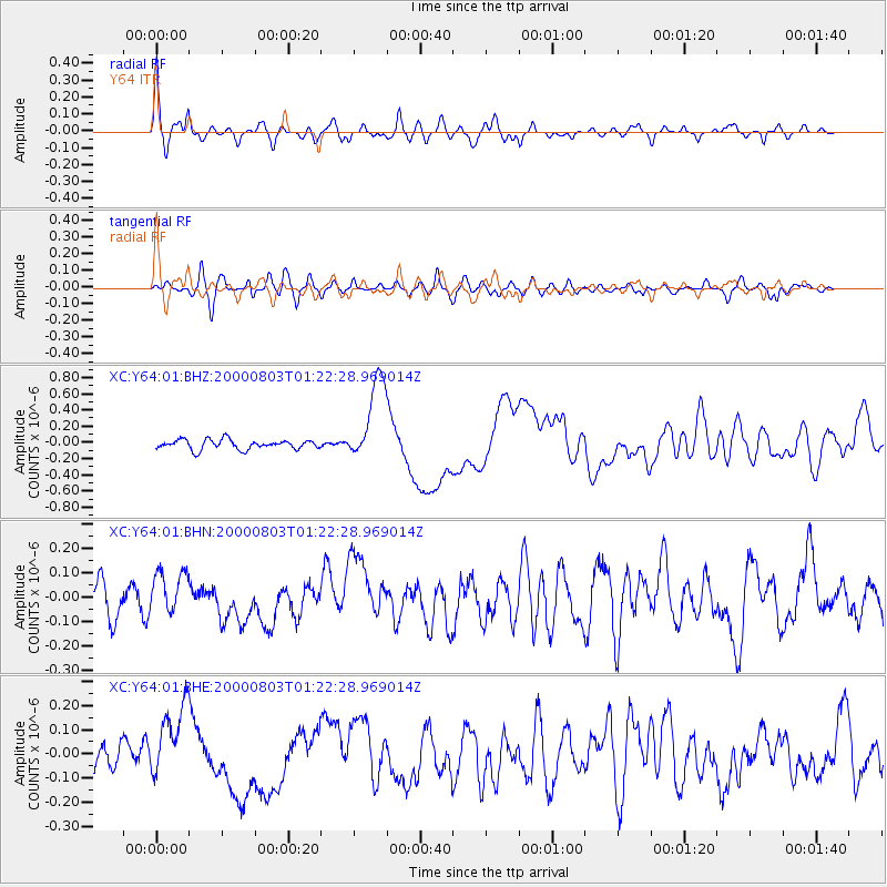
Earthquake location: Santa Cruz Islands
Earthquake latitude/longitude: -12.0/166.4
Earthquake time(UTC): 2000/08/03 (216) 01:09:38 GMT
Earthquake Depth: 33 km
Earthquake Magnitude: 5.7 MB, 6.5 MS, 6.7 MW, 6.6 MW
Earthquake Catalog/Contributor: WHDF/NEIC
Network: XC Yellowstone Intermountain Seismic Array
Station: Y64 Y64
Lat/Lon: 44.11 N/107.47 W
Elevation: 1415 m
Distance: 95.5 deg
Az: 46.22 deg
Baz: 258.663 deg
Ray Param: 0.0407566
Estimated Moho Depth: 46.0 km
Estimated Crust Vp/Vs: 1.64
Assumed Crust Vp: 6.178 km/s
Estimated Crust Vs: 3.756 km/s
Estimated Crust Poisson's Ratio: 0.21
Radial Match: 80.06748 %
Radial Bump: 400
Transverse Match: 54.768753 %
Transverse Bump: 400
SOD ConfigId: 16820
Insert Time: 2010-02-26 15:03:40.682 +0000
GWidth: 2.5
Max Bumps: 400
Tol: 0.001

Signal To Noise

ChannelStoNSTALTA
XC:Y64:01:BHN:20000803T01:22:28.969014Z1.41271328.393034E-85.941074E-8
XC:Y64:01:BHE:20000803T01:22:28.969014Z2.67431571.527799E-75.7128595E-8
XC:Y64:01:BHZ:20000803T01:22:28.969014Z8.8254445.2703444E-75.9717614E-8
Arrivals
Ps4.9 SECOND
PpPs19 SECOND
PsPs/PpSs24 SECOND