You are here: Home > Network List > XC00 - Yellowstone Intermountain Seismic Array Stations List
> Station Y64 Y64 > Earthquake Result Viewer
Y64 Y64 - Earthquake Result Viewer
| Earthquake location: |
Bonin Islands, Japan Region |
| Earthquake latitude/longitude: |
26.3/140.5 |
| Earthquake time(UTC): |
2000/10/27 (301) 04:21:51 GMT |
| Earthquake Depth: |
388 km |
| Earthquake Magnitude: |
6.1 MB, 6.1 MW, 6.0 MW |
| Earthquake Catalog/Contributor: |
WHDF/NEIC |
|
| Network: |
XC Yellowstone Intermountain Seismic Array |
| Station: |
Y64 Y64 |
| Lat/Lon: |
44.11 N/107.47 W |
| Elevation: |
1415 m |
|
| Distance: |
86.4 deg |
| Az: |
41.984 deg |
| Baz: |
303.512 deg |
| Ray Param: |
0.04304929 |
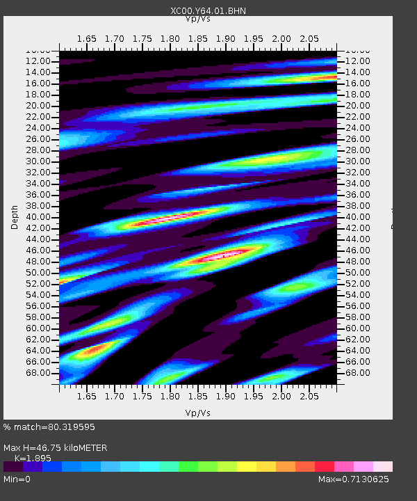
| Estimated Moho Depth: |
46.75 km |
| Estimated Crust Vp/Vs: |
1.89 |
| Assumed Crust Vp: |
6.178 km/s |
| Estimated Crust Vs: |
3.26 km/s |
| Estimated Crust Poisson's Ratio: |
0.31 |
|
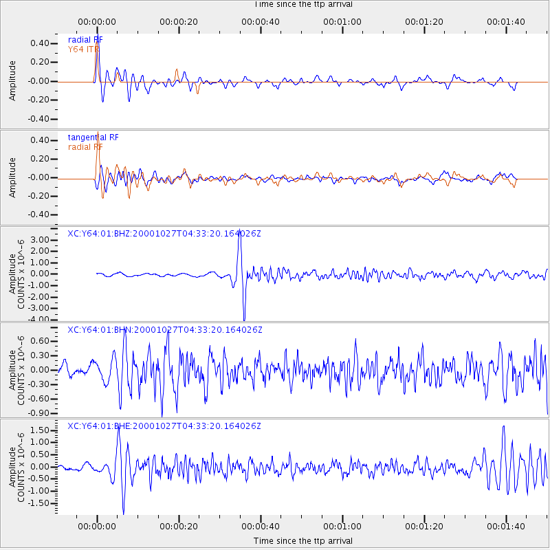
| Radial Match: |
80.319595 % |
| Radial Bump: |
341 |
| Transverse Match: |
72.32844 % |
| Transverse Bump: |
400 |
| SOD ConfigId: |
16820 |
| Insert Time: |
2010-02-26 15:03:43.026 +0000 |
| GWidth: |
2.5 |
| Max Bumps: |
400 |
| Tol: |
0.001 |
|
Signal To Noise
| Channel | StoN | STA | LTA |
| XC:Y64:01:BHN:20001027T04:33:20.164026Z | 1.4567829 | 2.3749253E-7 | 1.6302535E-7 |
| XC:Y64:01:BHE:20001027T04:33:20.164026Z | 2.4124534 | 3.1623517E-7 | 1.3108446E-7 |
| XC:Y64:01:BHZ:20001027T04:33:20.164026Z | 8.219299 | 9.2449335E-7 | 1.1247837E-7 |
| Arrivals |
| Ps | 6.9 SECOND |
| PpPs | 21 SECOND |
| PsPs/PpSs | 28 SECOND |


