You are here: Home > Network List > TA - USArray Transportable Network (new EarthScope stations) Stations List
> Station C23K Itkillik River, AK, USA > Earthquake Result Viewer
C23K Itkillik River, AK, USA - Earthquake Result Viewer
| Earthquake location: |
Costa Rica |
| Earthquake latitude/longitude: |
9.6/-84.6 |
| Earthquake time(UTC): |
2020/08/24 (237) 21:51:09 GMT |
| Earthquake Depth: |
19 km |
| Earthquake Magnitude: |
6.0 mww |
| Earthquake Catalog/Contributor: |
NEIC PDE/us |
|
| Network: |
TA USArray Transportable Network (new EarthScope stations) |
| Station: |
C23K Itkillik River, AK, USA |
| Lat/Lon: |
69.84 N/150.61 W |
| Elevation: |
179 m |
|
| Distance: |
72.9 deg |
| Az: |
340.646 deg |
| Baz: |
109.512 deg |
| Ray Param: |
0.053355776 |
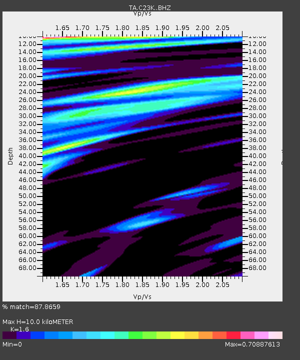
| Estimated Moho Depth: |
10.0 km |
| Estimated Crust Vp/Vs: |
1.60 |
| Assumed Crust Vp: |
6.221 km/s |
| Estimated Crust Vs: |
3.888 km/s |
| Estimated Crust Poisson's Ratio: |
0.18 |
|
| Radial Match: |
87.8659 % |
| Radial Bump: |
400 |
| Transverse Match: |
79.92201 % |
| Transverse Bump: |
400 |
| SOD ConfigId: |
21709731 |
| Insert Time: |
2020-09-07 22:14:34.311 +0000 |
| GWidth: |
2.5 |
| Max Bumps: |
400 |
| Tol: |
0.001 |
|

Signal To Noise
| Channel | StoN | STA | LTA |
| TA:C23K: :BHZ:20200824T22:02:05.550029Z | 11.016713 | 7.197048E-7 | 6.532845E-8 |
| TA:C23K: :BHN:20200824T22:02:05.550029Z | 2.433766 | 1.2624906E-7 | 5.1873958E-8 |
| TA:C23K: :BHE:20200824T22:02:05.550029Z | 3.791427 | 1.8366242E-7 | 4.8441503E-8 |
| Arrivals |
| Ps | 1.0 SECOND |
| PpPs | 4.0 SECOND |
| PsPs/PpSs | 5.0 SECOND |


