You are here: Home > Network List > TA - USArray Transportable Network (new EarthScope stations) Stations List
> Station D17K Noatak River, AK, USA > Earthquake Result Viewer
D17K Noatak River, AK, USA - Earthquake Result Viewer
| Earthquake location: |
Costa Rica |
| Earthquake latitude/longitude: |
9.6/-84.6 |
| Earthquake time(UTC): |
2020/08/24 (237) 21:51:09 GMT |
| Earthquake Depth: |
19 km |
| Earthquake Magnitude: |
6.0 mww |
| Earthquake Catalog/Contributor: |
NEIC PDE/us |
|
| Network: |
TA USArray Transportable Network (new EarthScope stations) |
| Station: |
D17K Noatak River, AK, USA |
| Lat/Lon: |
67.70 N/163.08 W |
| Elevation: |
172 m |
|
| Distance: |
76.8 deg |
| Az: |
337.415 deg |
| Baz: |
97.045 deg |
| Ray Param: |
0.05072663 |
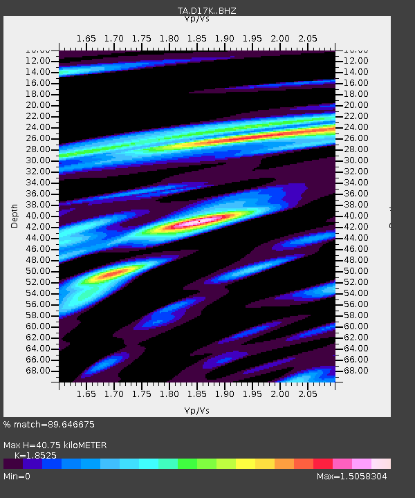
| Estimated Moho Depth: |
40.75 km |
| Estimated Crust Vp/Vs: |
1.85 |
| Assumed Crust Vp: |
6.276 km/s |
| Estimated Crust Vs: |
3.388 km/s |
| Estimated Crust Poisson's Ratio: |
0.29 |
|
| Radial Match: |
89.646675 % |
| Radial Bump: |
400 |
| Transverse Match: |
78.0384 % |
| Transverse Bump: |
400 |
| SOD ConfigId: |
21709731 |
| Insert Time: |
2020-09-07 22:14:39.913 +0000 |
| GWidth: |
2.5 |
| Max Bumps: |
400 |
| Tol: |
0.001 |
|

Signal To Noise
| Channel | StoN | STA | LTA |
| TA:D17K: :BHZ:20200824T22:02:28.199993Z | 15.889866 | 4.1408842E-7 | 2.6059906E-8 |
| TA:D17K: :BHN:20200824T22:02:28.199993Z | 2.4395695 | 5.7381595E-8 | 2.3521197E-8 |
| TA:D17K: :BHE:20200824T22:02:28.199993Z | 7.609644 | 2.4058238E-7 | 3.1615457E-8 |
| Arrivals |
| Ps | 5.7 SECOND |
| PpPs | 18 SECOND |
| PsPs/PpSs | 24 SECOND |


