You are here: Home > Network List > TA - USArray Transportable Network (new EarthScope stations) Stations List
> Station E17K Hotham Inlet, AK, USA > Earthquake Result Viewer
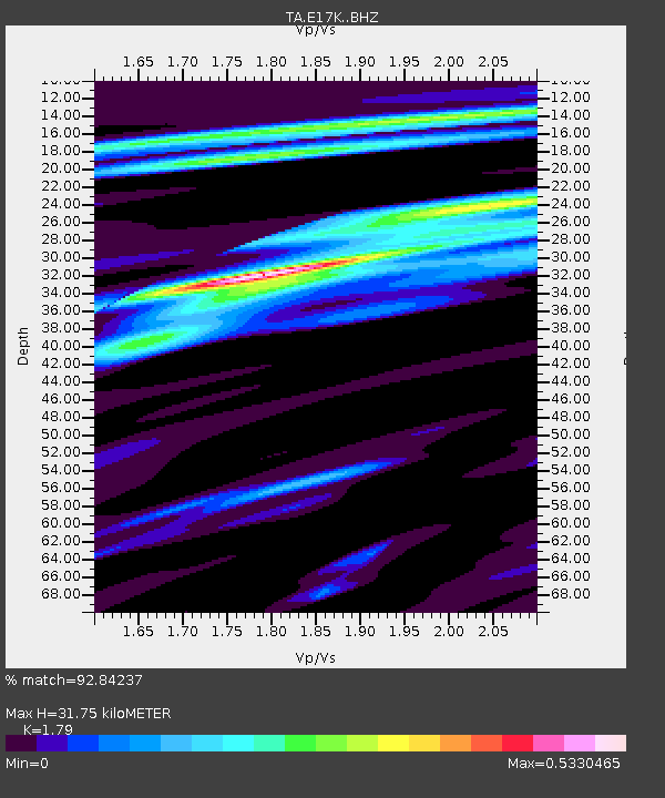
E17K Hotham Inlet, AK, USA - Earthquake Result Viewer
| Earthquake location: |
Costa Rica |
| Earthquake latitude/longitude: |
9.6/-84.6 |
| Earthquake time(UTC): |
2020/08/24 (237) 21:51:09 GMT |
| Earthquake Depth: |
19 km |
| Earthquake Magnitude: |
6.0 mww |
| Earthquake Catalog/Contributor: |
NEIC PDE/us |
|
| Network: |
TA USArray Transportable Network (new EarthScope stations) |
| Station: |
E17K Hotham Inlet, AK, USA |
| Lat/Lon: |
67.08 N/161.83 W |
| Elevation: |
233 m |
|
| Distance: |
76.3 deg |
| Az: |
336.849 deg |
| Baz: |
98.072 deg |
| Ray Param: |
0.0511083 |
| Estimated Moho Depth: |
31.75 km |
| Estimated Crust Vp/Vs: |
1.79 |
| Assumed Crust Vp: |
6.276 km/s |
| Estimated Crust Vs: |
3.506 km/s |
| Estimated Crust Poisson's Ratio: |
0.27 |
|
| Radial Match: |
92.84237 % |
| Radial Bump: |
291 |
| Transverse Match: |
85.72436 % |
| Transverse Bump: |
400 |
| SOD ConfigId: |
21709731 |
| Insert Time: |
2020-09-07 22:14:53.461 +0000 |
| GWidth: |
2.5 |
| Max Bumps: |
400 |
| Tol: |
0.001 |
|

Signal To Noise
| Channel | StoN | STA | LTA |
| TA:E17K: :BHZ:20200824T22:02:25.025005Z | 10.273441 | 4.779172E-7 | 4.6519677E-8 |
| TA:E17K: :BHN:20200824T22:02:25.025005Z | 2.4561353 | 8.134441E-8 | 3.3118862E-8 |
| TA:E17K: :BHE:20200824T22:02:25.025005Z | 7.2109466 | 1.7915147E-7 | 2.4844377E-8 |
| Arrivals |
| Ps | 4.1 SECOND |
| PpPs | 14 SECOND |
| PsPs/PpSs | 18 SECOND |


