You are here: Home > Network List > US - United States National Seismic Network Stations List
> Station EGMT Eagleton, Montana, USA > Earthquake Result Viewer
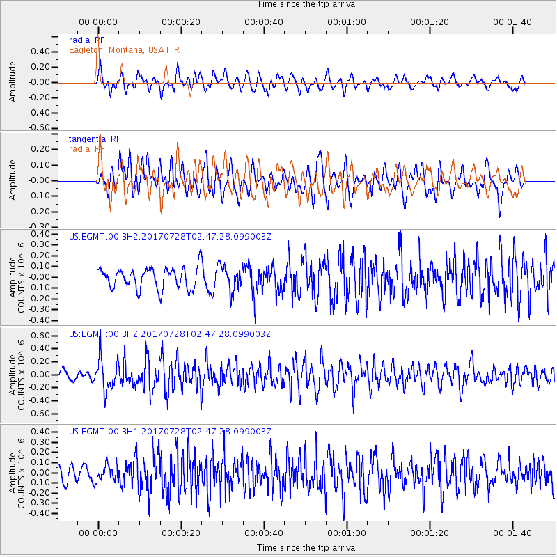
EGMT Eagleton, Montana, USA - Earthquake Result Viewer
*The percent match for this event was below the threshold and hence no stack was calculated.
| Earthquake location: |
Komandorskiye Ostrova Region |
| Earthquake latitude/longitude: |
54.3/169.3 |
| Earthquake time(UTC): |
2017/07/28 (209) 02:39:16 GMT |
| Earthquake Depth: |
10 km |
| Earthquake Magnitude: |
5.5 mb |
| Earthquake Catalog/Contributor: |
NEIC PDE/us |
|
| Network: |
US United States National Seismic Network |
| Station: |
EGMT Eagleton, Montana, USA |
| Lat/Lon: |
48.02 N/109.75 W |
| Elevation: |
1055 m |
|
| Distance: |
48.5 deg |
| Az: |
62.259 deg |
| Baz: |
309.45 deg |
| Ray Param: |
$rayparam |
*The percent match for this event was below the threshold and hence was not used in the summary stack. |
|
| Radial Match: |
59.014095 % |
| Radial Bump: |
400 |
| Transverse Match: |
64.28482 % |
| Transverse Bump: |
400 |
| SOD ConfigId: |
2140511 |
| Insert Time: |
2017-08-10 18:35:56.487 +0000 |
| GWidth: |
2.5 |
| Max Bumps: |
400 |
| Tol: |
0.001 |
|
Signal To Noise
| Channel | StoN | STA | LTA |
| US:EGMT:00:BHZ:20170728T02:47:28.099003Z | 4.2141156 | 2.5265734E-7 | 5.9955006E-8 |
| US:EGMT:00:BH1:20170728T02:47:28.099003Z | 1.1915612 | 8.059644E-8 | 6.763936E-8 |
| US:EGMT:00:BH2:20170728T02:47:28.099003Z | 1.1963478 | 1.1448487E-7 | 9.56953E-8 |
| Arrivals |
| Ps | |
| PpPs | |
| PsPs/PpSs | |


