You are here: Home > Network List > TA - USArray Transportable Network (new EarthScope stations) Stations List
> Station H17K Granite Mountain, AK, USA > Earthquake Result Viewer
H17K Granite Mountain, AK, USA - Earthquake Result Viewer
| Earthquake location: |
Costa Rica |
| Earthquake latitude/longitude: |
9.6/-84.6 |
| Earthquake time(UTC): |
2020/08/24 (237) 21:51:09 GMT |
| Earthquake Depth: |
19 km |
| Earthquake Magnitude: |
6.0 mww |
| Earthquake Catalog/Contributor: |
NEIC PDE/us |
|
| Network: |
TA USArray Transportable Network (new EarthScope stations) |
| Station: |
H17K Granite Mountain, AK, USA |
| Lat/Lon: |
64.94 N/159.91 W |
| Elevation: |
396 m |
|
| Distance: |
75.2 deg |
| Az: |
334.773 deg |
| Baz: |
99.306 deg |
| Ray Param: |
0.051843576 |
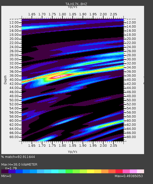
| Estimated Moho Depth: |
38.0 km |
| Estimated Crust Vp/Vs: |
1.79 |
| Assumed Crust Vp: |
6.1 km/s |
| Estimated Crust Vs: |
3.408 km/s |
| Estimated Crust Poisson's Ratio: |
0.27 |
|
| Radial Match: |
92.911644 % |
| Radial Bump: |
400 |
| Transverse Match: |
71.891365 % |
| Transverse Bump: |
400 |
| SOD ConfigId: |
21709731 |
| Insert Time: |
2020-09-07 22:15:49.002 +0000 |
| GWidth: |
2.5 |
| Max Bumps: |
400 |
| Tol: |
0.001 |
|

Signal To Noise
| Channel | StoN | STA | LTA |
| TA:H17K: :BHZ:20200824T22:02:18.74998Z | 16.700762 | 5.946628E-7 | 3.560693E-8 |
| TA:H17K: :BHN:20200824T22:02:18.74998Z | 1.5737598 | 5.2372037E-8 | 3.327829E-8 |
| TA:H17K: :BHE:20200824T22:02:18.74998Z | 7.603463 | 2.451307E-7 | 3.223935E-8 |
| Arrivals |
| Ps | 5.1 SECOND |
| PpPs | 17 SECOND |
| PsPs/PpSs | 22 SECOND |


