You are here: Home > Network List > XC00 - Yellowstone Intermountain Seismic Array Stations List
> Station Y64 Y64 > Earthquake Result Viewer
Y64 Y64 - Earthquake Result Viewer
| Earthquake location: |
Kuril Islands |
| Earthquake latitude/longitude: |
48.5/153.3 |
| Earthquake time(UTC): |
2001/02/14 (045) 13:36:39 GMT |
| Earthquake Depth: |
148 km |
| Earthquake Magnitude: |
5.8 MB, 5.6 MW, 5.6 MW |
| Earthquake Catalog/Contributor: |
WHDF/NEIC |
|
| Network: |
XC Yellowstone Intermountain Seismic Array |
| Station: |
Y64 Y64 |
| Lat/Lon: |
44.11 N/107.47 W |
| Elevation: |
1415 m |
|
| Distance: |
63.8 deg |
| Az: |
52.418 deg |
| Baz: |
313.026 deg |
| Ray Param: |
0.0589108 |
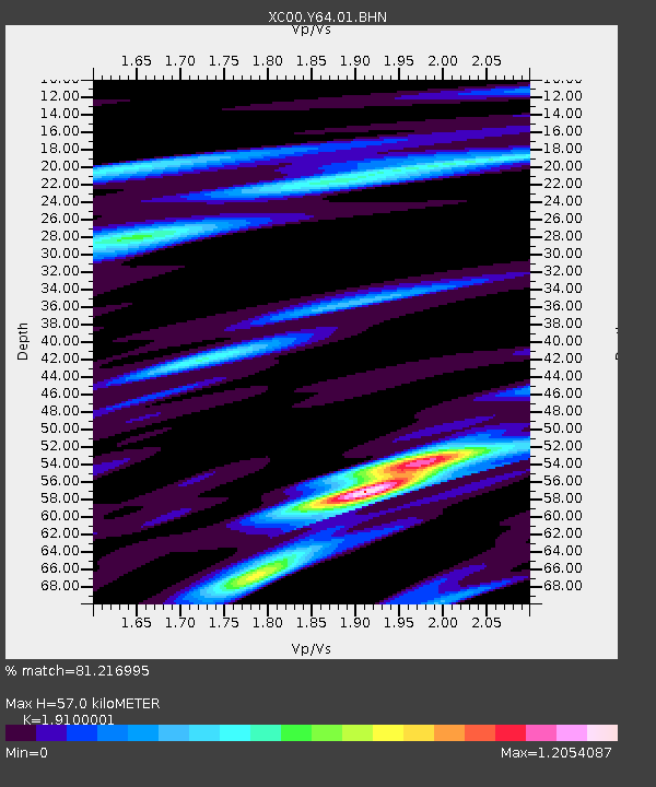
| Estimated Moho Depth: |
57.0 km |
| Estimated Crust Vp/Vs: |
1.91 |
| Assumed Crust Vp: |
6.178 km/s |
| Estimated Crust Vs: |
3.235 km/s |
| Estimated Crust Poisson's Ratio: |
0.31 |
|
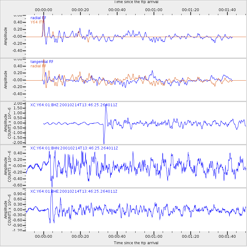
| Radial Match: |
81.216995 % |
| Radial Bump: |
400 |
| Transverse Match: |
58.100098 % |
| Transverse Bump: |
400 |
| SOD ConfigId: |
3753 |
| Insert Time: |
2010-02-26 15:03:46.299 +0000 |
| GWidth: |
2.5 |
| Max Bumps: |
400 |
| Tol: |
0.001 |
|
Signal To Noise
| Channel | StoN | STA | LTA |
| XC:Y64:01:BHN:20010214T13:46:25.264011Z | 2.558894 | 2.6792281E-7 | 1.04702586E-7 |
| XC:Y64:01:BHE:20010214T13:46:25.264011Z | 2.6673841 | 4.432135E-7 | 1.6616036E-7 |
| XC:Y64:01:BHZ:20010214T13:46:25.264011Z | 11.415738 | 8.5082496E-7 | 7.453088E-8 |
| Arrivals |
| Ps | 8.7 SECOND |
| PpPs | 26 SECOND |
| PsPs/PpSs | 35 SECOND |


