You are here: Home > Network List > WY - Yellowstone Wyoming Seismic Network Stations List
> Station YHH Holmes Hill, YNP, WY, USA > Earthquake Result Viewer
YHH Holmes Hill, YNP, WY, USA - Earthquake Result Viewer
| Earthquake location: |
Costa Rica |
| Earthquake latitude/longitude: |
9.6/-84.6 |
| Earthquake time(UTC): |
2020/08/24 (237) 21:51:09 GMT |
| Earthquake Depth: |
19 km |
| Earthquake Magnitude: |
6.0 mww |
| Earthquake Catalog/Contributor: |
NEIC PDE/us |
|
| Network: |
WY Yellowstone Wyoming Seismic Network |
| Station: |
YHH Holmes Hill, YNP, WY, USA |
| Lat/Lon: |
44.79 N/110.85 W |
| Elevation: |
2717 m |
|
| Distance: |
41.8 deg |
| Az: |
331.806 deg |
| Baz: |
139.128 deg |
| Ray Param: |
0.07357093 |
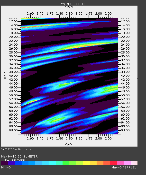
| Estimated Moho Depth: |
15.25 km |
| Estimated Crust Vp/Vs: |
1.61 |
| Assumed Crust Vp: |
6.35 km/s |
| Estimated Crust Vs: |
3.95 km/s |
| Estimated Crust Poisson's Ratio: |
0.18 |
|
| Radial Match: |
84.60987 % |
| Radial Bump: |
355 |
| Transverse Match: |
54.08514 % |
| Transverse Bump: |
400 |
| SOD ConfigId: |
21709731 |
| Insert Time: |
2020-09-07 22:22:00.131 +0000 |
| GWidth: |
2.5 |
| Max Bumps: |
400 |
| Tol: |
0.001 |
|

Signal To Noise
| Channel | StoN | STA | LTA |
| WY:YHH:01:HHZ:20200824T21:58:26.17799Z | 12.524351 | 1.1983224E-8 | 9.56794E-10 |
| WY:YHH:01:HHN:20200824T21:58:26.17799Z | 3.7649179 | 4.9792575E-9 | 1.3225407E-9 |
| WY:YHH:01:HHE:20200824T21:58:26.17799Z | 1.9419833 | 4.0790376E-9 | 2.1004494E-9 |
| Arrivals |
| Ps | 1.6 SECOND |
| PpPs | 5.8 SECOND |
| PsPs/PpSs | 7.4 SECOND |


