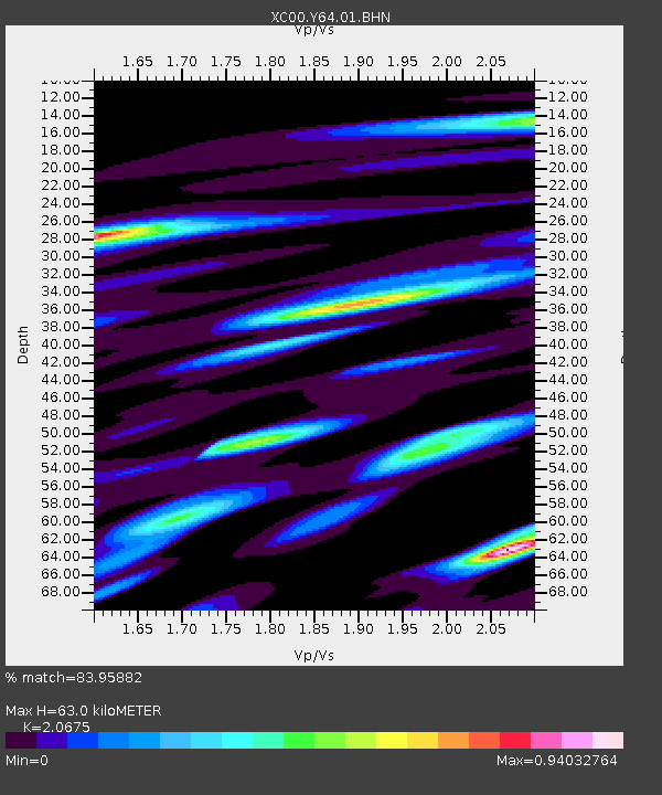
Y64 Y64 - Earthquake Result Viewer
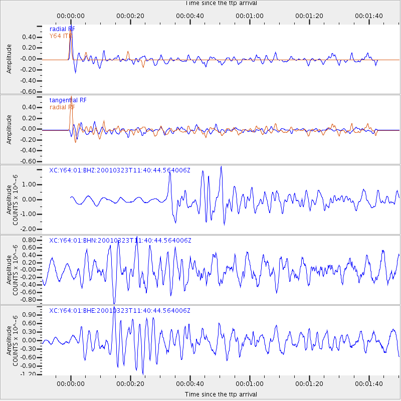
Earthquake location: Kuril Islands
Earthquake latitude/longitude: 44.1/148.1
Earthquake time(UTC): 2001/03/23 (082) 11:30:10 GMT
Earthquake Depth: 33 km
Earthquake Magnitude: 5.9 MB, 5.7 MS, 6.0 MW, 5.9 MW
Earthquake Catalog/Contributor: WHDF/NEIC
Network: XC Yellowstone Intermountain Seismic Array
Station: Y64 Y64
Lat/Lon: 44.11 N/107.47 W
Elevation: 1415 m
Distance: 69.5 deg
Az: 48.152 deg
Baz: 311.811 deg
Ray Param: 0.055586733
Estimated Moho Depth: 63.0 km
Estimated Crust Vp/Vs: 2.07
Assumed Crust Vp: 6.178 km/s
Estimated Crust Vs: 2.988 km/s
Estimated Crust Poisson's Ratio: 0.35
Radial Match: 83.95882 %
Radial Bump: 400
Transverse Match: 70.43942 %
Transverse Bump: 400
SOD ConfigId: 4714
Insert Time: 2010-02-26 15:03:48.249 +0000
GWidth: 2.5
Max Bumps: 400
Tol: 0.001

Signal To Noise

ChannelStoNSTALTA
XC:Y64:01:BHN:20010323T11:40:44.564006Z1.03066722.1054232E-72.0427771E-7
XC:Y64:01:BHE:20010323T11:40:44.564006Z2.1117272.5863943E-71.224777E-7
XC:Y64:01:BHZ:20010323T11:40:44.564006Z4.3509227.3155906E-71.6813885E-7
Arrivals
Ps11 SECOND
PpPs30 SECOND
PsPs/PpSs42 SECOND