You are here: Home > Network List > AV - Alaska Volcano Observatory Stations List
> Station SPCR Ckakachatna River, Mount Spurr, Alaska > Earthquake Result Viewer
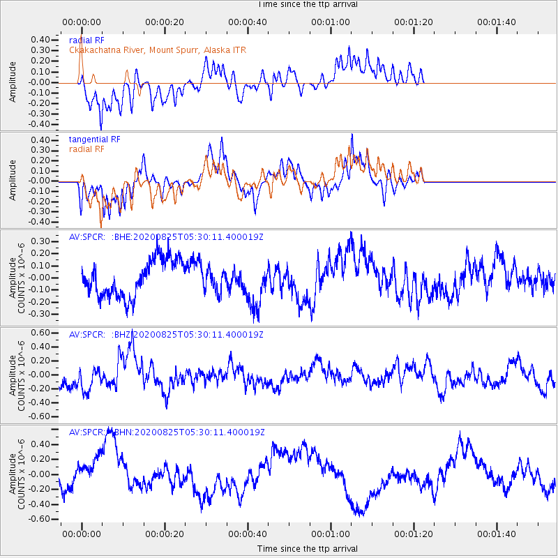
SPCR Ckakachatna River, Mount Spurr, Alaska - Earthquake Result Viewer
*The percent match for this event was below the threshold and hence no stack was calculated.
| Earthquake location: |
Peru-Ecuador Border Region |
| Earthquake latitude/longitude: |
-4.0/-80.8 |
| Earthquake time(UTC): |
2020/08/25 (238) 05:18:12 GMT |
| Earthquake Depth: |
33 km |
| Earthquake Magnitude: |
5.5 Mww |
| Earthquake Catalog/Contributor: |
NEIC PDE/us |
|
| Network: |
AV Alaska Volcano Observatory |
| Station: |
SPCR Ckakachatna River, Mount Spurr, Alaska |
| Lat/Lon: |
61.20 N/152.21 W |
| Elevation: |
984 m |
|
| Distance: |
84.7 deg |
| Az: |
332.554 deg |
| Baz: |
108.287 deg |
| Ray Param: |
$rayparam |
*The percent match for this event was below the threshold and hence was not used in the summary stack. |
|
| Radial Match: |
69.33168 % |
| Radial Bump: |
400 |
| Transverse Match: |
46.86157 % |
| Transverse Bump: |
301 |
| SOD ConfigId: |
21709731 |
| Insert Time: |
2020-09-08 05:23:01.553 +0000 |
| GWidth: |
2.5 |
| Max Bumps: |
400 |
| Tol: |
0.001 |
|
Signal To Noise
| Channel | StoN | STA | LTA |
| AV:SPCR: :BHZ:20200825T05:30:11.400019Z | 1.1566445 | 1.6478425E-7 | 1.4246751E-7 |
| AV:SPCR: :BHN:20200825T05:30:11.400019Z | 1.6901398 | 2.1651299E-7 | 1.281036E-7 |
| AV:SPCR: :BHE:20200825T05:30:11.400019Z | 0.5987264 | 8.953206E-8 | 1.4953751E-7 |
| Arrivals |
| Ps | |
| PpPs | |
| PsPs/PpSs | |


