You are here: Home > Network List > GS - US Geological Survey Networks Stations List
> Station ASA1 ASA1 > Earthquake Result Viewer
ASA1 ASA1 - Earthquake Result Viewer
| Earthquake location: |
Peru-Ecuador Border Region |
| Earthquake latitude/longitude: |
-4.0/-80.8 |
| Earthquake time(UTC): |
2020/08/25 (238) 05:18:12 GMT |
| Earthquake Depth: |
33 km |
| Earthquake Magnitude: |
5.5 Mww |
| Earthquake Catalog/Contributor: |
NEIC PDE/us |
|
| Network: |
GS US Geological Survey Networks |
| Station: |
ASA1 ASA1 |
| Lat/Lon: |
34.95 N/106.46 W |
| Elevation: |
1829 m |
|
| Distance: |
45.7 deg |
| Az: |
330.198 deg |
| Baz: |
142.877 deg |
| Ray Param: |
0.07106918 |
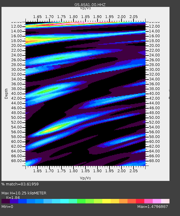
| Estimated Moho Depth: |
10.25 km |
| Estimated Crust Vp/Vs: |
1.84 |
| Assumed Crust Vp: |
6.502 km/s |
| Estimated Crust Vs: |
3.533 km/s |
| Estimated Crust Poisson's Ratio: |
0.29 |
|
| Radial Match: |
83.61959 % |
| Radial Bump: |
328 |
| Transverse Match: |
65.98607 % |
| Transverse Bump: |
399 |
| SOD ConfigId: |
21709731 |
| Insert Time: |
2020-09-08 05:30:31.241 +0000 |
| GWidth: |
2.5 |
| Max Bumps: |
400 |
| Tol: |
0.001 |
|

Signal To Noise
| Channel | StoN | STA | LTA |
| GS:ASA1:00:HHZ:20200825T05:25:59.129999Z | 4.284349 | 2.1228878E-7 | 4.9549836E-8 |
| GS:ASA1:00:HH1:20200825T05:25:59.129999Z | 3.2534318 | 1.3036926E-7 | 4.0071303E-8 |
| GS:ASA1:00:HH2:20200825T05:25:59.129999Z | 2.3213265 | 9.466111E-8 | 4.0778886E-8 |
| Arrivals |
| Ps | 1.4 SECOND |
| PpPs | 4.2 SECOND |
| PsPs/PpSs | 5.6 SECOND |


