You are here: Home > Network List > AU - Australian Seismological Centre Stations List
> Station TOO Toolangi, Victoria > Earthquake Result Viewer
TOO Toolangi, Victoria - Earthquake Result Viewer
| Earthquake location: |
Fiji Islands Region |
| Earthquake latitude/longitude: |
-17.3/-177.3 |
| Earthquake time(UTC): |
2008/07/19 (201) 22:39:52 GMT |
| Earthquake Depth: |
391 km |
| Earthquake Magnitude: |
5.9 MB, 6.4 MW, 6.4 MW |
| Earthquake Catalog/Contributor: |
WHDF/NEIC |
|
| Network: |
AU Australian Seismological Centre |
| Station: |
TOO Toolangi, Victoria |
| Lat/Lon: |
37.57 S/145.49 E |
| Elevation: |
604 m |
|
| Distance: |
38.3 deg |
| Az: |
230.75 deg |
| Baz: |
68.572 deg |
| Ray Param: |
0.07391519 |
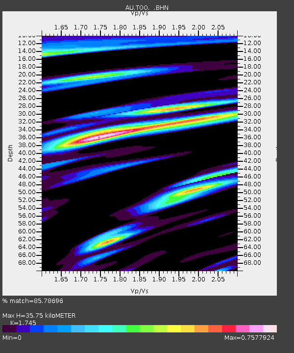
| Estimated Moho Depth: |
35.75 km |
| Estimated Crust Vp/Vs: |
1.75 |
| Assumed Crust Vp: |
6.577 km/s |
| Estimated Crust Vs: |
3.769 km/s |
| Estimated Crust Poisson's Ratio: |
0.26 |
|
| Radial Match: |
85.78696 % |
| Radial Bump: |
320 |
| Transverse Match: |
72.660095 % |
| Transverse Bump: |
398 |
| SOD ConfigId: |
2504 |
| Insert Time: |
2010-03-09 00:27:01.697 +0000 |
| GWidth: |
2.5 |
| Max Bumps: |
400 |
| Tol: |
0.001 |
|

Signal To Noise
| Channel | StoN | STA | LTA |
| AU:TOO: :BHN:20080719T22:46:07.344012Z | 29.18873 | 1.0439941E-5 | 3.576703E-7 |
| AU:TOO: :BHE:20080719T22:46:07.344012Z | 12.912981 | 2.9149483E-6 | 2.2573784E-7 |
| AU:TOO: :BHZ:20080719T22:46:07.344012Z | 21.01457 | 5.541548E-6 | 2.637003E-7 |
| Arrivals |
| Ps | 4.4 SECOND |
| PpPs | 14 SECOND |
| PsPs/PpSs | 18 SECOND |


