You are here: Home > Network List > IW - Intermountain West Stations List
> Station PLID Pearl Lake, Idaho, USA > Earthquake Result Viewer
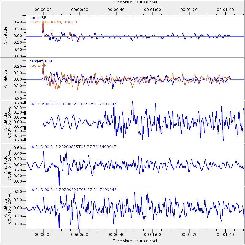
PLID Pearl Lake, Idaho, USA - Earthquake Result Viewer
*The percent match for this event was below the threshold and hence no stack was calculated.
| Earthquake location: |
Peru-Ecuador Border Region |
| Earthquake latitude/longitude: |
-4.0/-80.8 |
| Earthquake time(UTC): |
2020/08/25 (238) 05:18:12 GMT |
| Earthquake Depth: |
33 km |
| Earthquake Magnitude: |
5.5 Mww |
| Earthquake Catalog/Contributor: |
NEIC PDE/us |
|
| Network: |
IW Intermountain West |
| Station: |
PLID Pearl Lake, Idaho, USA |
| Lat/Lon: |
45.09 N/116.00 W |
| Elevation: |
2164 m |
|
| Distance: |
58.1 deg |
| Az: |
331.271 deg |
| Baz: |
137.401 deg |
| Ray Param: |
$rayparam |
*The percent match for this event was below the threshold and hence was not used in the summary stack. |
|
| Radial Match: |
70.9261 % |
| Radial Bump: |
400 |
| Transverse Match: |
58.92782 % |
| Transverse Bump: |
400 |
| SOD ConfigId: |
21709731 |
| Insert Time: |
2020-09-08 05:31:52.917 +0000 |
| GWidth: |
2.5 |
| Max Bumps: |
400 |
| Tol: |
0.001 |
|
Signal To Noise
| Channel | StoN | STA | LTA |
| IW:PLID:00:BHZ:20200825T05:27:31.749994Z | 2.376496 | 1.9469395E-7 | 8.1924796E-8 |
| IW:PLID:00:BH1:20200825T05:27:31.749994Z | 1.7377002 | 4.493492E-8 | 2.5858844E-8 |
| IW:PLID:00:BH2:20200825T05:27:31.749994Z | 1.1111792 | 4.451214E-8 | 4.005847E-8 |
| Arrivals |
| Ps | |
| PpPs | |
| PsPs/PpSs | |


