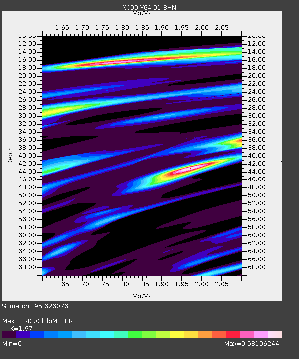
Y64 Y64 - Earthquake Result Viewer
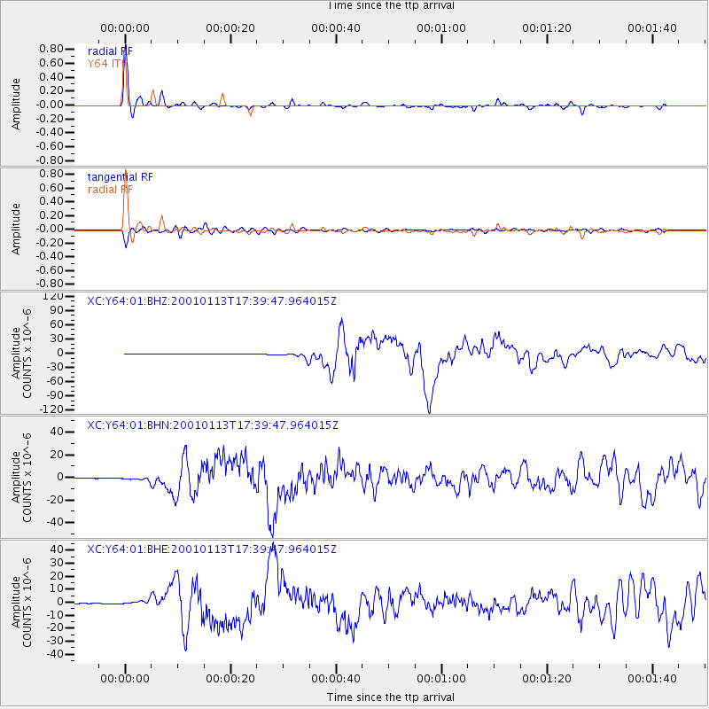
Earthquake location: El Salvador
Earthquake latitude/longitude: 13.0/-88.7
Earthquake time(UTC): 2001/01/13 (013) 17:33:32 GMT
Earthquake Depth: 60 km
Earthquake Magnitude: 6.4 MB, 7.8 MS, 7.7 MW, 7.5 ME
Earthquake Catalog/Contributor: WHDF/NEIC
Network: XC Yellowstone Intermountain Seismic Array
Station: Y64 Y64
Lat/Lon: 44.11 N/107.47 W
Elevation: 1415 m
Distance: 34.9 deg
Az: 336.045 deg
Baz: 146.684 deg
Ray Param: 0.077342376
Estimated Moho Depth: 43.0 km
Estimated Crust Vp/Vs: 1.97
Assumed Crust Vp: 6.178 km/s
Estimated Crust Vs: 3.136 km/s
Estimated Crust Poisson's Ratio: 0.33
Radial Match: 95.626076 %
Radial Bump: 252
Transverse Match: 85.93385 %
Transverse Bump: 400
SOD ConfigId: 16820
Insert Time: 2010-02-26 15:03:50.524 +0000
GWidth: 2.5
Max Bumps: 400
Tol: 0.001

Signal To Noise

ChannelStoNSTALTA
XC:Y64:01:BHN:20010113T17:39:47.964015Z6.66230251.6226012E-62.435496E-7
XC:Y64:01:BHE:20010113T17:39:47.964015Z8.25289251.8795735E-62.2774724E-7
XC:Y64:01:BHZ:20010113T17:39:47.964015Z35.4322665.9814442E-61.6881347E-7
Arrivals
Ps7.2 SECOND
PpPs19 SECOND
PsPs/PpSs27 SECOND