You are here: Home > Network List > TX - Texas Seismological Network Stations List
> Station WTFS Witchita Falls > Earthquake Result Viewer
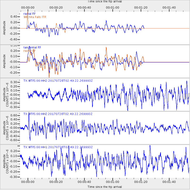
WTFS Witchita Falls - Earthquake Result Viewer
*The percent match for this event was below the threshold and hence no stack was calculated.
| Earthquake location: |
Komandorskiye Ostrova Region |
| Earthquake latitude/longitude: |
54.3/169.3 |
| Earthquake time(UTC): |
2017/07/28 (209) 02:39:16 GMT |
| Earthquake Depth: |
10 km |
| Earthquake Magnitude: |
5.5 mb |
| Earthquake Catalog/Contributor: |
NEIC PDE/us |
|
| Network: |
TX Texas Seismological Network |
| Station: |
WTFS Witchita Falls |
| Lat/Lon: |
33.77 N/98.46 W |
| Elevation: |
277 m |
|
| Distance: |
64.6 deg |
| Az: |
67.158 deg |
| Baz: |
319.614 deg |
| Ray Param: |
$rayparam |
*The percent match for this event was below the threshold and hence was not used in the summary stack. |
|
| Radial Match: |
61.66429 % |
| Radial Bump: |
400 |
| Transverse Match: |
60.698765 % |
| Transverse Bump: |
400 |
| SOD ConfigId: |
2140511 |
| Insert Time: |
2017-08-10 18:38:41.877 +0000 |
| GWidth: |
2.5 |
| Max Bumps: |
400 |
| Tol: |
0.001 |
|
Signal To Noise
| Channel | StoN | STA | LTA |
| TX:WTFS:00:HHZ:20170728T02:49:22.269993Z | 3.5454407 | 2.6525353E-7 | 7.481539E-8 |
| TX:WTFS:00:HH1:20170728T02:49:22.269993Z | 0.80750275 | 6.5535E-8 | 8.1157616E-8 |
| TX:WTFS:00:HH2:20170728T02:49:22.269993Z | 1.2400924 | 7.641151E-8 | 6.16176E-8 |
| Arrivals |
| Ps | |
| PpPs | |
| PsPs/PpSs | |


