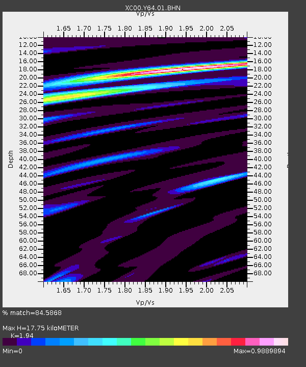
Y64 Y64 - Earthquake Result Viewer
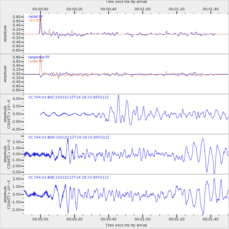
Earthquake location: El Salvador
Earthquake latitude/longitude: 13.7/-88.9
Earthquake time(UTC): 2001/02/13 (044) 14:22:05 GMT
Earthquake Depth: 10 km
Earthquake Magnitude: 5.5 MB, 6.5 MS, 6.6 MW, 6.1 MD
Earthquake Catalog/Contributor: WHDF/NEIC
Network: XC Yellowstone Intermountain Seismic Array
Station: Y64 Y64
Lat/Lon: 44.11 N/107.47 W
Elevation: 1415 m
Distance: 34.2 deg
Az: 335.975 deg
Baz: 146.677 deg
Ray Param: 0.07784349
Estimated Moho Depth: 17.75 km
Estimated Crust Vp/Vs: 1.94
Assumed Crust Vp: 6.178 km/s
Estimated Crust Vs: 3.185 km/s
Estimated Crust Poisson's Ratio: 0.32
Radial Match: 84.5868 %
Radial Bump: 292
Transverse Match: 59.783894 %
Transverse Bump: 400
SOD ConfigId: 3744
Insert Time: 2010-02-26 15:03:51.820 +0000
GWidth: 2.5
Max Bumps: 400
Tol: 0.001

Signal To Noise

ChannelStoNSTALTA
XC:Y64:01:BHN:20010213T14:28:20.865013Z0.646081452.0730528E-73.2086555E-7
XC:Y64:01:BHE:20010213T14:28:20.865013Z0.90565732.457554E-72.7135584E-7
XC:Y64:01:BHZ:20010213T14:28:20.865013Z1.21860893.3154097E-72.720651E-7
Arrivals
Ps2.9 SECOND
PpPs7.9 SECOND
PsPs/PpSs11 SECOND