You are here: Home > Network List > XC00 - Yellowstone Intermountain Seismic Array Stations List
> Station Y64 Y64 > Earthquake Result Viewer
Y64 Y64 - Earthquake Result Viewer
| Earthquake location: |
Fiji Islands Region |
| Earthquake latitude/longitude: |
-18.1/-176.9 |
| Earthquake time(UTC): |
2001/04/28 (118) 04:49:53 GMT |
| Earthquake Depth: |
352 km |
| Earthquake Magnitude: |
6.2 MB, 6.8 MW, 6.8 MW |
| Earthquake Catalog/Contributor: |
WHDF/NEIC |
|
| Network: |
XC Yellowstone Intermountain Seismic Array |
| Station: |
Y64 Y64 |
| Lat/Lon: |
44.11 N/107.47 W |
| Elevation: |
1415 m |
|
| Distance: |
88.5 deg |
| Az: |
42.442 deg |
| Baz: |
243.021 deg |
| Ray Param: |
0.04172878 |
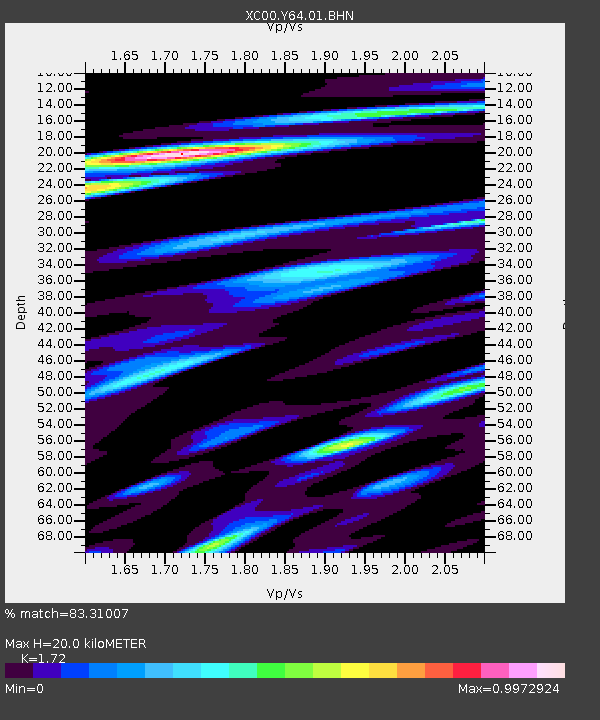
| Estimated Moho Depth: |
20.0 km |
| Estimated Crust Vp/Vs: |
1.72 |
| Assumed Crust Vp: |
6.178 km/s |
| Estimated Crust Vs: |
3.592 km/s |
| Estimated Crust Poisson's Ratio: |
0.24 |
|
| Radial Match: |
83.31007 % |
| Radial Bump: |
400 |
| Transverse Match: |
64.93841 % |
| Transverse Bump: |
400 |
| SOD ConfigId: |
4714 |
| Insert Time: |
2010-02-26 15:03:54.918 +0000 |
| GWidth: |
2.5 |
| Max Bumps: |
400 |
| Tol: |
0.001 |
|
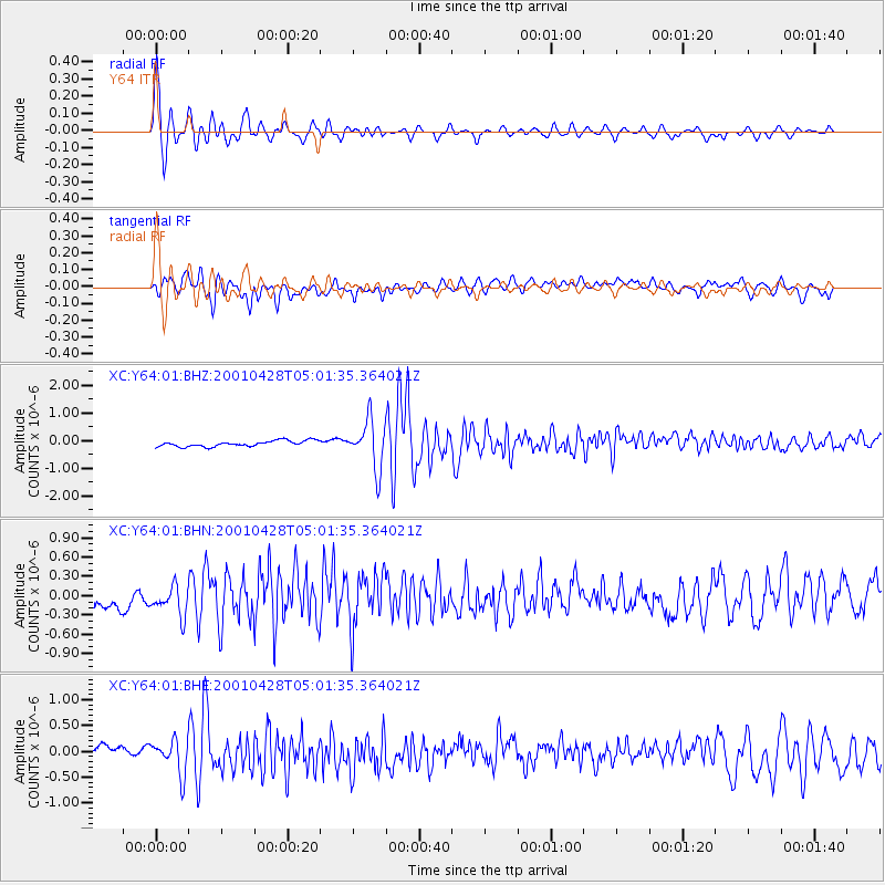
Signal To Noise
| Channel | StoN | STA | LTA |
| XC:Y64:01:BHN:20010428T05:01:35.364021Z | 1.3223683 | 2.5977457E-7 | 1.9644646E-7 |
| XC:Y64:01:BHE:20010428T05:01:35.364021Z | 2.8865108 | 3.3007598E-7 | 1.143512E-7 |
| XC:Y64:01:BHZ:20010428T05:01:35.364021Z | 8.330939 | 8.618393E-7 | 1.0345043E-7 |
| Arrivals |
| Ps | 2.4 SECOND |
| PpPs | 8.6 SECOND |
| PsPs/PpSs | 11 SECOND |


