You are here: Home > Network List > O2 - Oklahoma Consolidated Temporary Seismic Networks Stations List
> Station STIG Stigler, Oklahoma, USA > Earthquake Result Viewer
STIG Stigler, Oklahoma, USA - Earthquake Result Viewer
| Earthquake location: |
Peru-Ecuador Border Region |
| Earthquake latitude/longitude: |
-4.0/-80.8 |
| Earthquake time(UTC): |
2020/08/25 (238) 05:18:12 GMT |
| Earthquake Depth: |
33 km |
| Earthquake Magnitude: |
5.5 Mww |
| Earthquake Catalog/Contributor: |
NEIC PDE/us |
|
| Network: |
O2 Oklahoma Consolidated Temporary Seismic Networks |
| Station: |
STIG Stigler, Oklahoma, USA |
| Lat/Lon: |
35.34 N/95.11 W |
| Elevation: |
256 m |
|
| Distance: |
41.4 deg |
| Az: |
342.243 deg |
| Baz: |
158.153 deg |
| Ray Param: |
0.07375192 |
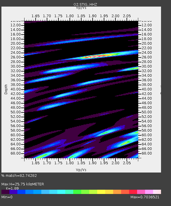
| Estimated Moho Depth: |
25.75 km |
| Estimated Crust Vp/Vs: |
1.89 |
| Assumed Crust Vp: |
6.498 km/s |
| Estimated Crust Vs: |
3.438 km/s |
| Estimated Crust Poisson's Ratio: |
0.31 |
|
| Radial Match: |
82.74282 % |
| Radial Bump: |
400 |
| Transverse Match: |
67.037476 % |
| Transverse Bump: |
400 |
| SOD ConfigId: |
21709731 |
| Insert Time: |
2020-09-08 05:38:07.210 +0000 |
| GWidth: |
2.5 |
| Max Bumps: |
400 |
| Tol: |
0.001 |
|

Signal To Noise
| Channel | StoN | STA | LTA |
| O2:STIG: :HHZ:20200825T05:25:24.904993Z | 5.4011064 | 5.1385695E-7 | 9.51392E-8 |
| O2:STIG: :HHN:20200825T05:25:24.904993Z | 4.077757 | 2.724777E-7 | 6.682049E-8 |
| O2:STIG: :HHE:20200825T05:25:24.904993Z | 2.4531806 | 1.6280542E-7 | 6.636504E-8 |
| Arrivals |
| Ps | 3.8 SECOND |
| PpPs | 11 SECOND |
| PsPs/PpSs | 14 SECOND |


