You are here: Home > Network List > XC00 - Yellowstone Intermountain Seismic Array Stations List
> Station Y64 Y64 > Earthquake Result Viewer
Y64 Y64 - Earthquake Result Viewer

| Earthquake location: |
Fiji Islands Region |
| Earthquake latitude/longitude: |
-19.9/-177.5 |
| Earthquake time(UTC): |
2001/05/19 (139) 17:36:25 GMT |
| Earthquake Depth: |
369 km |
| Earthquake Magnitude: |
5.9 MB, 6.0 MW, 5.9 MW |
| Earthquake Catalog/Contributor: |
WHDF/NEIC |
|
| Network: |
XC Yellowstone Intermountain Seismic Array |
| Station: |
Y64 Y64 |
| Lat/Lon: |
44.11 N/107.47 W |
| Elevation: |
1415 m |
|
| Distance: |
90.2 deg |
| Az: |
42.619 deg |
| Baz: |
242.188 deg |
| Ray Param: |
0.041601684 |
| Estimated Moho Depth: |
19.75 km |
| Estimated Crust Vp/Vs: |
1.74 |
| Assumed Crust Vp: |
6.178 km/s |
| Estimated Crust Vs: |
3.556 km/s |
| Estimated Crust Poisson's Ratio: |
0.25 |
|
| Radial Match: |
82.436714 % |
| Radial Bump: |
400 |
| Transverse Match: |
58.564148 % |
| Transverse Bump: |
400 |
| SOD ConfigId: |
4714 |
| Insert Time: |
2010-02-26 15:03:55.980 +0000 |
| GWidth: |
2.5 |
| Max Bumps: |
400 |
| Tol: |
0.001 |
|
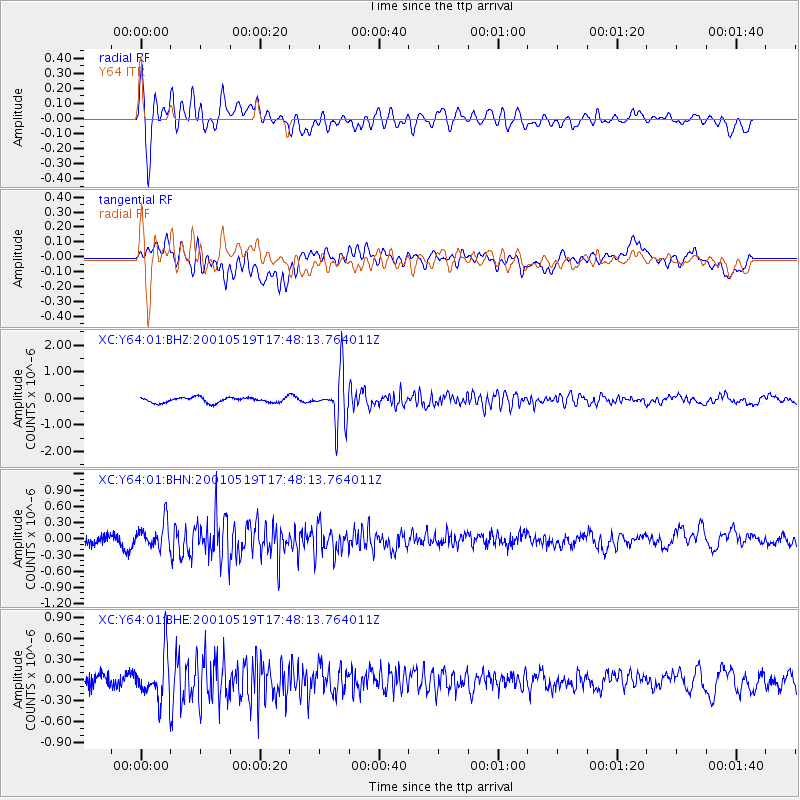
Signal To Noise
| Channel | StoN | STA | LTA |
| XC:Y64:01:BHN:20010519T17:48:13.764011Z | 2.2818677 | 2.3728681E-7 | 1.0398798E-7 |
| XC:Y64:01:BHE:20010519T17:48:13.764011Z | 3.4118605 | 3.3260548E-7 | 9.748507E-8 |
| XC:Y64:01:BHZ:20010519T17:48:13.764011Z | 9.033482 | 8.941192E-7 | 9.897836E-8 |
| Arrivals |
| Ps | 2.4 SECOND |
| PpPs | 8.6 SECOND |
| PsPs/PpSs | 11 SECOND |


