You are here: Home > Network List > TA - USArray Transportable Network (new EarthScope stations) Stations List
> Station F21K Alatna River, AK, USA > Earthquake Result Viewer
F21K Alatna River, AK, USA - Earthquake Result Viewer
| Earthquake location: |
Peru-Ecuador Border Region |
| Earthquake latitude/longitude: |
-4.0/-80.8 |
| Earthquake time(UTC): |
2020/08/25 (238) 05:18:12 GMT |
| Earthquake Depth: |
33 km |
| Earthquake Magnitude: |
5.5 Mww |
| Earthquake Catalog/Contributor: |
NEIC PDE/us |
|
| Network: |
TA USArray Transportable Network (new EarthScope stations) |
| Station: |
F21K Alatna River, AK, USA |
| Lat/Lon: |
67.22 N/153.48 W |
| Elevation: |
597 m |
|
| Distance: |
87.0 deg |
| Az: |
338.151 deg |
| Baz: |
107.545 deg |
| Ray Param: |
0.043563917 |
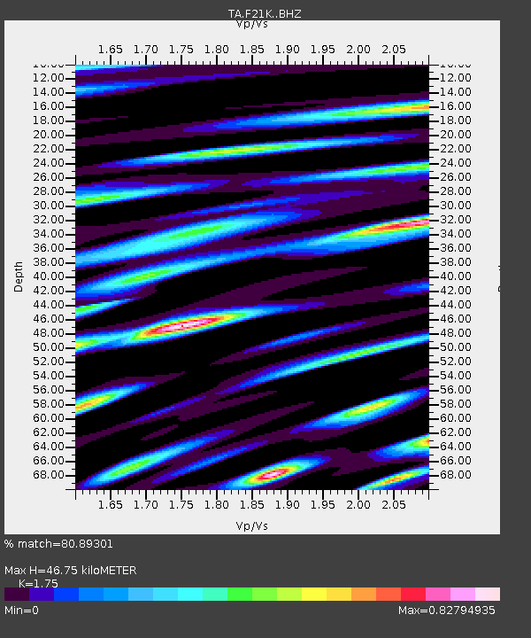
| Estimated Moho Depth: |
46.75 km |
| Estimated Crust Vp/Vs: |
1.75 |
| Assumed Crust Vp: |
6.455 km/s |
| Estimated Crust Vs: |
3.689 km/s |
| Estimated Crust Poisson's Ratio: |
0.26 |
|
| Radial Match: |
80.89301 % |
| Radial Bump: |
400 |
| Transverse Match: |
75.81986 % |
| Transverse Bump: |
400 |
| SOD ConfigId: |
21709731 |
| Insert Time: |
2020-09-08 05:41:42.408 +0000 |
| GWidth: |
2.5 |
| Max Bumps: |
400 |
| Tol: |
0.001 |
|

Signal To Noise
| Channel | StoN | STA | LTA |
| TA:F21K: :BHZ:20200825T05:30:23.200006Z | 5.736363 | 2.0673872E-7 | 3.6040035E-8 |
| TA:F21K: :BHN:20200825T05:30:23.200006Z | 1.1068888 | 2.4699832E-8 | 2.2314646E-8 |
| TA:F21K: :BHE:20200825T05:30:23.200006Z | 3.728363 | 6.542839E-8 | 1.7548825E-8 |
| Arrivals |
| Ps | 5.6 SECOND |
| PpPs | 19 SECOND |
| PsPs/PpSs | 25 SECOND |


