You are here: Home > Network List > TA - USArray Transportable Network (new EarthScope stations) Stations List
> Station F26K Sheenjek River, AK, USA > Earthquake Result Viewer
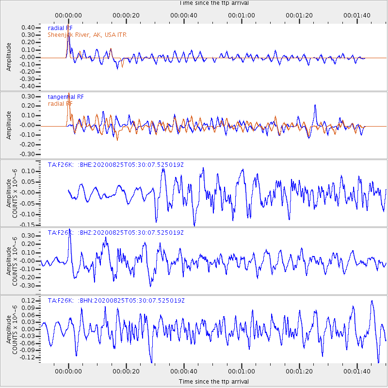
F26K Sheenjek River, AK, USA - Earthquake Result Viewer
*The percent match for this event was below the threshold and hence no stack was calculated.
| Earthquake location: |
Peru-Ecuador Border Region |
| Earthquake latitude/longitude: |
-4.0/-80.8 |
| Earthquake time(UTC): |
2020/08/25 (238) 05:18:12 GMT |
| Earthquake Depth: |
33 km |
| Earthquake Magnitude: |
5.5 Mww |
| Earthquake Catalog/Contributor: |
NEIC PDE/us |
|
| Network: |
TA USArray Transportable Network (new EarthScope stations) |
| Station: |
F26K Sheenjek River, AK, USA |
| Lat/Lon: |
67.69 N/144.15 W |
| Elevation: |
683 m |
|
| Distance: |
83.9 deg |
| Az: |
339.938 deg |
| Baz: |
116.305 deg |
| Ray Param: |
$rayparam |
*The percent match for this event was below the threshold and hence was not used in the summary stack. |
|
| Radial Match: |
79.707504 % |
| Radial Bump: |
400 |
| Transverse Match: |
74.74473 % |
| Transverse Bump: |
400 |
| SOD ConfigId: |
21709731 |
| Insert Time: |
2020-09-08 05:41:48.054 +0000 |
| GWidth: |
2.5 |
| Max Bumps: |
400 |
| Tol: |
0.001 |
|
Signal To Noise
| Channel | StoN | STA | LTA |
| TA:F26K: :BHZ:20200825T05:30:07.525019Z | 4.6000667 | 1.6524467E-7 | 3.5922234E-8 |
| TA:F26K: :BHN:20200825T05:30:07.525019Z | 1.6552099 | 5.114297E-8 | 3.089818E-8 |
| TA:F26K: :BHE:20200825T05:30:07.525019Z | 3.202506 | 7.258838E-8 | 2.2666118E-8 |
| Arrivals |
| Ps | |
| PpPs | |
| PsPs/PpSs | |


