You are here: Home > Network List > TA - USArray Transportable Network (new EarthScope stations) Stations List
> Station G16K Koyuk River, AK, USA > Earthquake Result Viewer
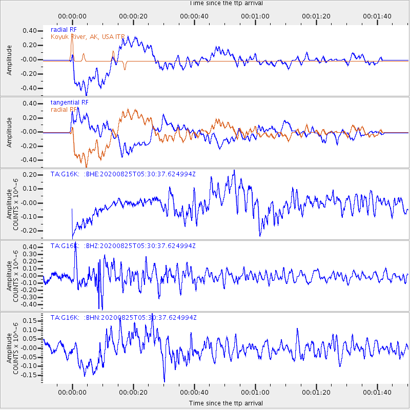
G16K Koyuk River, AK, USA - Earthquake Result Viewer
*The percent match for this event was below the threshold and hence no stack was calculated.
| Earthquake location: |
Peru-Ecuador Border Region |
| Earthquake latitude/longitude: |
-4.0/-80.8 |
| Earthquake time(UTC): |
2020/08/25 (238) 05:18:12 GMT |
| Earthquake Depth: |
33 km |
| Earthquake Magnitude: |
5.5 Mww |
| Earthquake Catalog/Contributor: |
NEIC PDE/us |
|
| Network: |
TA USArray Transportable Network (new EarthScope stations) |
| Station: |
G16K Koyuk River, AK, USA |
| Lat/Lon: |
65.39 N/162.35 W |
| Elevation: |
169 m |
|
| Distance: |
90.1 deg |
| Az: |
335.535 deg |
| Baz: |
99.362 deg |
| Ray Param: |
$rayparam |
*The percent match for this event was below the threshold and hence was not used in the summary stack. |
|
| Radial Match: |
56.1627 % |
| Radial Bump: |
400 |
| Transverse Match: |
41.673103 % |
| Transverse Bump: |
400 |
| SOD ConfigId: |
21709731 |
| Insert Time: |
2020-09-08 05:41:55.037 +0000 |
| GWidth: |
2.5 |
| Max Bumps: |
400 |
| Tol: |
0.001 |
|
Signal To Noise
| Channel | StoN | STA | LTA |
| TA:G16K: :BHZ:20200825T05:30:37.624994Z | 2.8971303 | 1.552734E-7 | 5.3595585E-8 |
| TA:G16K: :BHN:20200825T05:30:37.624994Z | 0.97562236 | 6.132606E-8 | 6.2858405E-8 |
| TA:G16K: :BHE:20200825T05:30:37.624994Z | 1.0120028 | 7.1178135E-8 | 7.033393E-8 |
| Arrivals |
| Ps | |
| PpPs | |
| PsPs/PpSs | |


