You are here: Home > Network List > TA - USArray Transportable Network (new EarthScope stations) Stations List
> Station L15K Ungalak Mountain, AK, USA > Earthquake Result Viewer
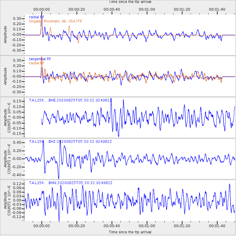
L15K Ungalak Mountain, AK, USA - Earthquake Result Viewer
*The percent match for this event was below the threshold and hence no stack was calculated.
| Earthquake location: |
Peru-Ecuador Border Region |
| Earthquake latitude/longitude: |
-4.0/-80.8 |
| Earthquake time(UTC): |
2020/08/25 (238) 05:18:12 GMT |
| Earthquake Depth: |
33 km |
| Earthquake Magnitude: |
5.5 Mww |
| Earthquake Catalog/Contributor: |
NEIC PDE/us |
|
| Network: |
TA USArray Transportable Network (new EarthScope stations) |
| Station: |
L15K Ungalak Mountain, AK, USA |
| Lat/Lon: |
61.68 N/161.49 W |
| Elevation: |
219 m |
|
| Distance: |
89.1 deg |
| Az: |
331.924 deg |
| Baz: |
100.113 deg |
| Ray Param: |
$rayparam |
*The percent match for this event was below the threshold and hence was not used in the summary stack. |
|
| Radial Match: |
71.76076 % |
| Radial Bump: |
400 |
| Transverse Match: |
69.36987 % |
| Transverse Bump: |
400 |
| SOD ConfigId: |
21709731 |
| Insert Time: |
2020-09-08 05:42:43.501 +0000 |
| GWidth: |
2.5 |
| Max Bumps: |
400 |
| Tol: |
0.001 |
|
Signal To Noise
| Channel | StoN | STA | LTA |
| TA:L15K: :BHZ:20200825T05:30:32.924982Z | 5.1123877 | 1.8623817E-7 | 3.64288E-8 |
| TA:L15K: :BHN:20200825T05:30:32.924982Z | 1.5416895 | 4.9608236E-8 | 3.2177837E-8 |
| TA:L15K: :BHE:20200825T05:30:32.924982Z | 1.699356 | 5.1657782E-8 | 3.0398446E-8 |
| Arrivals |
| Ps | |
| PpPs | |
| PsPs/PpSs | |


