You are here: Home > Network List > TA - USArray Transportable Network (new EarthScope stations) Stations List
> Station R31K City Hall, Gustavus, AK, USA > Earthquake Result Viewer
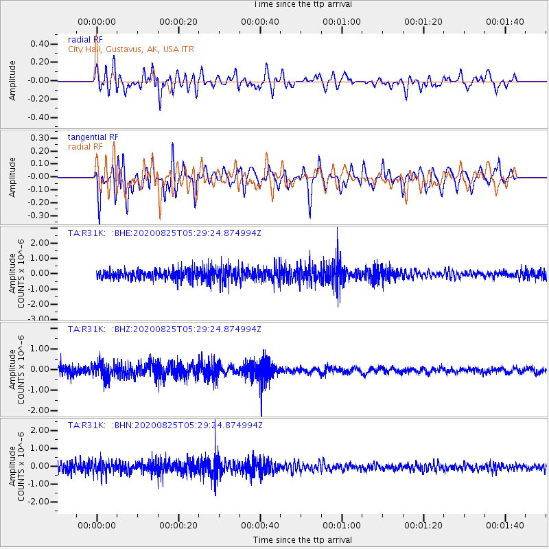
R31K City Hall, Gustavus, AK, USA - Earthquake Result Viewer
*The percent match for this event was below the threshold and hence no stack was calculated.
| Earthquake location: |
Peru-Ecuador Border Region |
| Earthquake latitude/longitude: |
-4.0/-80.8 |
| Earthquake time(UTC): |
2020/08/25 (238) 05:18:12 GMT |
| Earthquake Depth: |
33 km |
| Earthquake Magnitude: |
5.5 Mww |
| Earthquake Catalog/Contributor: |
NEIC PDE/us |
|
| Network: |
TA USArray Transportable Network (new EarthScope stations) |
| Station: |
R31K City Hall, Gustavus, AK, USA |
| Lat/Lon: |
58.41 N/135.74 W |
| Elevation: |
15 m |
|
| Distance: |
76.0 deg |
| Az: |
333.644 deg |
| Baz: |
122.711 deg |
| Ray Param: |
$rayparam |
*The percent match for this event was below the threshold and hence was not used in the summary stack. |
|
| Radial Match: |
58.292522 % |
| Radial Bump: |
400 |
| Transverse Match: |
62.465923 % |
| Transverse Bump: |
400 |
| SOD ConfigId: |
21709731 |
| Insert Time: |
2020-09-08 05:43:23.876 +0000 |
| GWidth: |
2.5 |
| Max Bumps: |
400 |
| Tol: |
0.001 |
|
Signal To Noise
| Channel | StoN | STA | LTA |
| TA:R31K: :BHZ:20200825T05:29:24.874994Z | 2.2631361 | 3.525173E-7 | 1.5576497E-7 |
| TA:R31K: :BHN:20200825T05:29:24.874994Z | 1.7950276 | 3.3398368E-7 | 1.8606048E-7 |
| TA:R31K: :BHE:20200825T05:29:24.874994Z | 1.681707 | 4.6283358E-7 | 2.7521654E-7 |
| Arrivals |
| Ps | |
| PpPs | |
| PsPs/PpSs | |


