You are here: Home > Network List > TA - USArray Transportable Network (new EarthScope stations) Stations List
> Station R33M Jennings River, BC, CAN > Earthquake Result Viewer
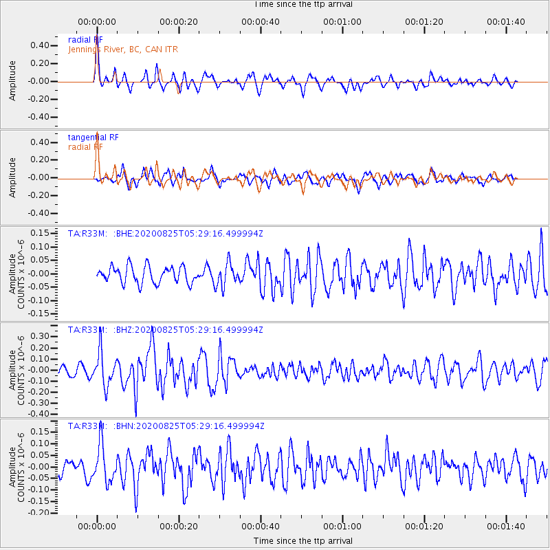
R33M Jennings River, BC, CAN - Earthquake Result Viewer
*The percent match for this event was below the threshold and hence no stack was calculated.
| Earthquake location: |
Peru-Ecuador Border Region |
| Earthquake latitude/longitude: |
-4.0/-80.8 |
| Earthquake time(UTC): |
2020/08/25 (238) 05:18:12 GMT |
| Earthquake Depth: |
33 km |
| Earthquake Magnitude: |
5.5 Mww |
| Earthquake Catalog/Contributor: |
NEIC PDE/us |
|
| Network: |
TA USArray Transportable Network (new EarthScope stations) |
| Station: |
R33M Jennings River, BC, CAN |
| Lat/Lon: |
59.39 N/130.97 W |
| Elevation: |
1437 m |
|
| Distance: |
74.5 deg |
| Az: |
335.947 deg |
| Baz: |
127.378 deg |
| Ray Param: |
$rayparam |
*The percent match for this event was below the threshold and hence was not used in the summary stack. |
|
| Radial Match: |
76.525246 % |
| Radial Bump: |
400 |
| Transverse Match: |
55.29967 % |
| Transverse Bump: |
400 |
| SOD ConfigId: |
21709731 |
| Insert Time: |
2020-09-08 05:43:26.224 +0000 |
| GWidth: |
2.5 |
| Max Bumps: |
400 |
| Tol: |
0.001 |
|
Signal To Noise
| Channel | StoN | STA | LTA |
| TA:R33M: :BHZ:20200825T05:29:16.499994Z | 5.231305 | 1.5569223E-7 | 2.976164E-8 |
| TA:R33M: :BHN:20200825T05:29:16.499994Z | 2.732202 | 8.2519286E-8 | 3.0202482E-8 |
| TA:R33M: :BHE:20200825T05:29:16.499994Z | 1.3942028 | 4.2611266E-8 | 3.0563175E-8 |
| Arrivals |
| Ps | |
| PpPs | |
| PsPs/PpSs | |


