You are here: Home > Network List > TX - Texas Seismological Network Stations List
> Station SMWD Samnorwood > Earthquake Result Viewer
SMWD Samnorwood - Earthquake Result Viewer
| Earthquake location: |
Peru-Ecuador Border Region |
| Earthquake latitude/longitude: |
-4.0/-80.8 |
| Earthquake time(UTC): |
2020/08/25 (238) 05:18:12 GMT |
| Earthquake Depth: |
33 km |
| Earthquake Magnitude: |
5.5 Mww |
| Earthquake Catalog/Contributor: |
NEIC PDE/us |
|
| Network: |
TX Texas Seismological Network |
| Station: |
SMWD Samnorwood |
| Lat/Lon: |
35.10 N/100.24 W |
| Elevation: |
704 m |
|
| Distance: |
43.0 deg |
| Az: |
336.439 deg |
| Baz: |
150.9 deg |
| Ray Param: |
0.07276988 |
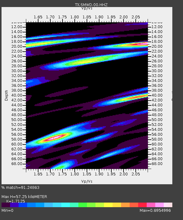
| Estimated Moho Depth: |
57.25 km |
| Estimated Crust Vp/Vs: |
1.71 |
| Assumed Crust Vp: |
6.426 km/s |
| Estimated Crust Vs: |
3.752 km/s |
| Estimated Crust Poisson's Ratio: |
0.24 |
|
| Radial Match: |
91.24863 % |
| Radial Bump: |
261 |
| Transverse Match: |
88.8423 % |
| Transverse Bump: |
337 |
| SOD ConfigId: |
21709731 |
| Insert Time: |
2020-09-08 05:44:52.196 +0000 |
| GWidth: |
2.5 |
| Max Bumps: |
400 |
| Tol: |
0.001 |
|

Signal To Noise
| Channel | StoN | STA | LTA |
| TX:SMWD:00:HHZ:20200825T05:25:37.904993Z | 17.423122 | 6.758708E-7 | 3.87916E-8 |
| TX:SMWD:00:HH1:20200825T05:25:37.904993Z | 9.746859 | 4.2977297E-7 | 4.4093483E-8 |
| TX:SMWD:00:HH2:20200825T05:25:37.904993Z | 6.1786647 | 2.700372E-7 | 4.3704777E-8 |
| Arrivals |
| Ps | 6.8 SECOND |
| PpPs | 23 SECOND |
| PsPs/PpSs | 29 SECOND |


