You are here: Home > Network List > TX - Texas Seismological Network Stations List
> Station SN07 Snyder 07 > Earthquake Result Viewer
SN07 Snyder 07 - Earthquake Result Viewer
| Earthquake location: |
Peru-Ecuador Border Region |
| Earthquake latitude/longitude: |
-4.0/-80.8 |
| Earthquake time(UTC): |
2020/08/25 (238) 05:18:12 GMT |
| Earthquake Depth: |
33 km |
| Earthquake Magnitude: |
5.5 Mww |
| Earthquake Catalog/Contributor: |
NEIC PDE/us |
|
| Network: |
TX Texas Seismological Network |
| Station: |
SN07 Snyder 07 |
| Lat/Lon: |
33.09 N/100.89 W |
| Elevation: |
620 m |
|
| Distance: |
41.5 deg |
| Az: |
334.248 deg |
| Baz: |
148.916 deg |
| Ray Param: |
0.0736687 |
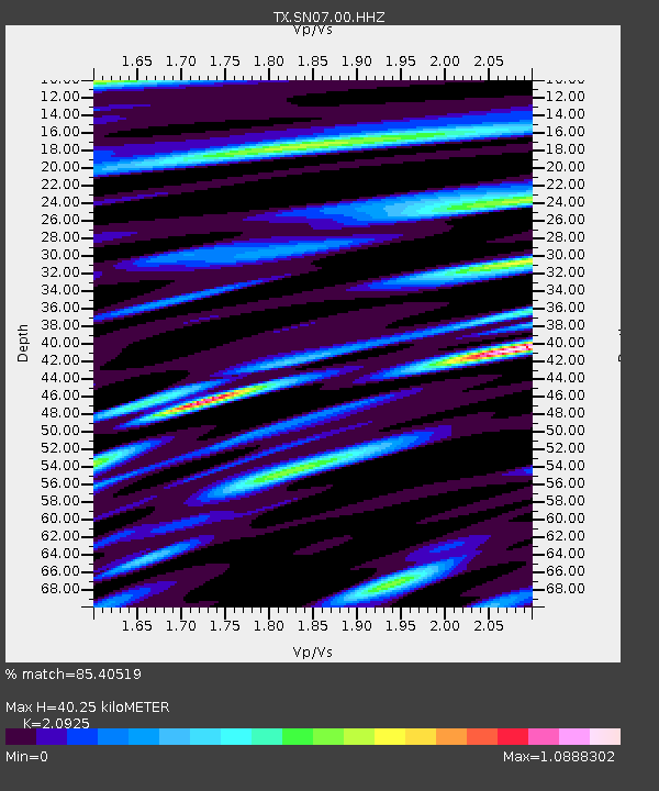
| Estimated Moho Depth: |
40.25 km |
| Estimated Crust Vp/Vs: |
2.09 |
| Assumed Crust Vp: |
6.426 km/s |
| Estimated Crust Vs: |
3.071 km/s |
| Estimated Crust Poisson's Ratio: |
0.35 |
|
| Radial Match: |
85.40519 % |
| Radial Bump: |
400 |
| Transverse Match: |
61.23965 % |
| Transverse Bump: |
400 |
| SOD ConfigId: |
21709731 |
| Insert Time: |
2020-09-08 05:44:55.881 +0000 |
| GWidth: |
2.5 |
| Max Bumps: |
400 |
| Tol: |
0.001 |
|

Signal To Noise
| Channel | StoN | STA | LTA |
| TX:SN07:00:HHZ:20200825T05:25:25.969995Z | 4.978177 | 2.2165639E-7 | 4.4525613E-8 |
| TX:SN07:00:HH1:20200825T05:25:25.969995Z | 2.466694 | 8.23151E-8 | 3.3370615E-8 |
| TX:SN07:00:HH2:20200825T05:25:25.969995Z | 2.2774768 | 8.617233E-8 | 3.7836756E-8 |
| Arrivals |
| Ps | 7.2 SECOND |
| PpPs | 18 SECOND |
| PsPs/PpSs | 26 SECOND |


