You are here: Home > Network List > US - United States National Seismic Network Stations List
> Station AMTX Amarillo, Texas, USA > Earthquake Result Viewer
AMTX Amarillo, Texas, USA - Earthquake Result Viewer
*The percent match for this event was below the threshold and hence no stack was calculated.
| Earthquake location: |
Peru-Ecuador Border Region |
| Earthquake latitude/longitude: |
-4.0/-80.8 |
| Earthquake time(UTC): |
2020/08/25 (238) 05:18:12 GMT |
| Earthquake Depth: |
33 km |
| Earthquake Magnitude: |
5.5 Mww |
| Earthquake Catalog/Contributor: |
NEIC PDE/us |
|
| Network: |
US United States National Seismic Network |
| Station: |
AMTX Amarillo, Texas, USA |
| Lat/Lon: |
34.53 N/101.41 W |
| Elevation: |
1010 m |
|
| Distance: |
43.0 deg |
| Az: |
334.8 deg |
| Baz: |
149.038 deg |
| Ray Param: |
$rayparam |
*The percent match for this event was below the threshold and hence was not used in the summary stack. |
|
| Radial Match: |
70.167206 % |
| Radial Bump: |
400 |
| Transverse Match: |
74.24612 % |
| Transverse Bump: |
400 |
| SOD ConfigId: |
21709731 |
| Insert Time: |
2020-09-08 05:45:40.401 +0000 |
| GWidth: |
2.5 |
| Max Bumps: |
400 |
| Tol: |
0.001 |
|
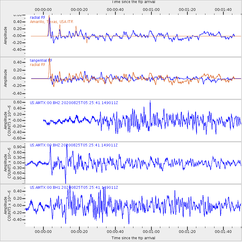
Signal To Noise
| Channel | StoN | STA | LTA |
| US:AMTX:00:BHZ:20200825T05:25:41.149011Z | 4.375762 | 2.984528E-7 | 6.82059E-8 |
| US:AMTX:00:BH1:20200825T05:25:41.149011Z | 1.3022628 | 9.171794E-8 | 7.042968E-8 |
| US:AMTX:00:BH2:20200825T05:25:41.149011Z | 1.327501 | 8.021659E-8 | 6.042676E-8 |
| Arrivals |
| Ps | |
| PpPs | |
| PsPs/PpSs | |


