You are here: Home > Network List > UW - Pacific Northwest Regional Seismic Network Stations List
> Station LEBA Lebam, WA, USA > Earthquake Result Viewer
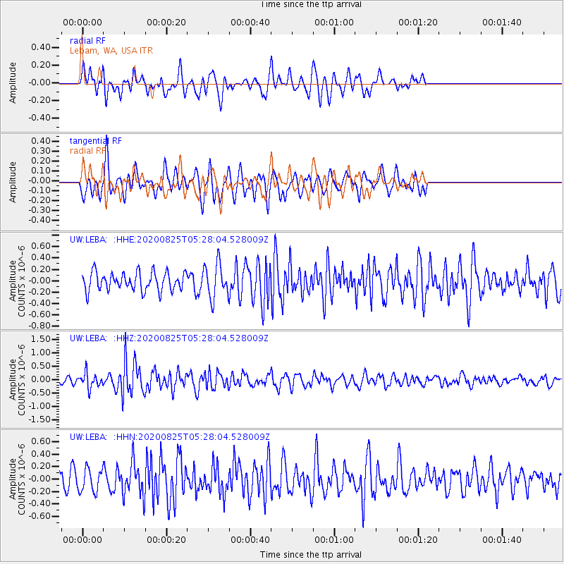
LEBA Lebam, WA, USA - Earthquake Result Viewer
*The percent match for this event was below the threshold and hence no stack was calculated.
| Earthquake location: |
Peru-Ecuador Border Region |
| Earthquake latitude/longitude: |
-4.0/-80.8 |
| Earthquake time(UTC): |
2020/08/25 (238) 05:18:12 GMT |
| Earthquake Depth: |
33 km |
| Earthquake Magnitude: |
5.5 Mww |
| Earthquake Catalog/Contributor: |
NEIC PDE/us |
|
| Network: |
UW Pacific Northwest Regional Seismic Network |
| Station: |
LEBA Lebam, WA, USA |
| Lat/Lon: |
46.55 N/123.56 W |
| Elevation: |
73 m |
|
| Distance: |
62.9 deg |
| Az: |
328.26 deg |
| Baz: |
130.507 deg |
| Ray Param: |
$rayparam |
*The percent match for this event was below the threshold and hence was not used in the summary stack. |
|
| Radial Match: |
52.02096 % |
| Radial Bump: |
400 |
| Transverse Match: |
75.60998 % |
| Transverse Bump: |
400 |
| SOD ConfigId: |
21709731 |
| Insert Time: |
2020-09-08 05:48:05.128 +0000 |
| GWidth: |
2.5 |
| Max Bumps: |
400 |
| Tol: |
0.001 |
|
Signal To Noise
| Channel | StoN | STA | LTA |
| UW:LEBA: :HHZ:20200825T05:28:04.528009Z | 2.595021 | 2.790673E-7 | 1.0753952E-7 |
| UW:LEBA: :HHN:20200825T05:28:04.528009Z | 1.0737861 | 1.8604932E-7 | 1.732648E-7 |
| UW:LEBA: :HHE:20200825T05:28:04.528009Z | 1.9232181 | 3.0511845E-7 | 1.5864994E-7 |
| Arrivals |
| Ps | |
| PpPs | |
| PsPs/PpSs | |


