You are here: Home > Network List > AK - Alaska Regional Network Stations List
> Station K20K Telida, AK, USA > Earthquake Result Viewer
K20K Telida, AK, USA - Earthquake Result Viewer
| Earthquake location: |
New Britain Region, P.N.G. |
| Earthquake latitude/longitude: |
-5.5/151.8 |
| Earthquake time(UTC): |
2020/08/25 (238) 19:02:59 GMT |
| Earthquake Depth: |
23 km |
| Earthquake Magnitude: |
5.7 Mww |
| Earthquake Catalog/Contributor: |
NEIC PDE/us |
|
| Network: |
AK Alaska Regional Network |
| Station: |
K20K Telida, AK, USA |
| Lat/Lon: |
63.36 N/154.07 W |
| Elevation: |
548 m |
|
| Distance: |
79.8 deg |
| Az: |
21.787 deg |
| Baz: |
235.032 deg |
| Ray Param: |
0.04871448 |
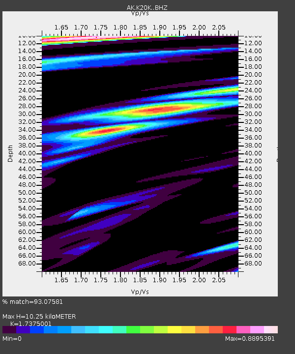
| Estimated Moho Depth: |
10.25 km |
| Estimated Crust Vp/Vs: |
1.74 |
| Assumed Crust Vp: |
6.438 km/s |
| Estimated Crust Vs: |
3.705 km/s |
| Estimated Crust Poisson's Ratio: |
0.25 |
|
| Radial Match: |
93.07581 % |
| Radial Bump: |
397 |
| Transverse Match: |
81.85749 % |
| Transverse Bump: |
378 |
| SOD ConfigId: |
21709731 |
| Insert Time: |
2020-09-08 19:05:03.669 +0000 |
| GWidth: |
2.5 |
| Max Bumps: |
400 |
| Tol: |
0.001 |
|

Signal To Noise
| Channel | StoN | STA | LTA |
| AK:K20K: :BHZ:20200825T19:14:33.859985Z | 19.166061 | 9.178902E-7 | 4.7891433E-8 |
| AK:K20K: :BHN:20200825T19:14:33.859985Z | 4.4908695 | 1.9231355E-7 | 4.2823235E-8 |
| AK:K20K: :BHE:20200825T19:14:33.859985Z | 8.597474 | 2.666251E-7 | 3.101203E-8 |
| Arrivals |
| Ps | 1.2 SECOND |
| PpPs | 4.2 SECOND |
| PsPs/PpSs | 5.4 SECOND |


