You are here: Home > Network List > AK - Alaska Regional Network Stations List
> Station M26K Nabesna, AK, USA > Earthquake Result Viewer
M26K Nabesna, AK, USA - Earthquake Result Viewer
| Earthquake location: |
New Britain Region, P.N.G. |
| Earthquake latitude/longitude: |
-5.5/151.8 |
| Earthquake time(UTC): |
2020/08/25 (238) 19:02:59 GMT |
| Earthquake Depth: |
23 km |
| Earthquake Magnitude: |
5.7 Mww |
| Earthquake Catalog/Contributor: |
NEIC PDE/us |
|
| Network: |
AK Alaska Regional Network |
| Station: |
M26K Nabesna, AK, USA |
| Lat/Lon: |
62.40 N/143.00 W |
| Elevation: |
888 m |
|
| Distance: |
83.7 deg |
| Az: |
25.169 deg |
| Baz: |
245.369 deg |
| Ray Param: |
0.045987718 |
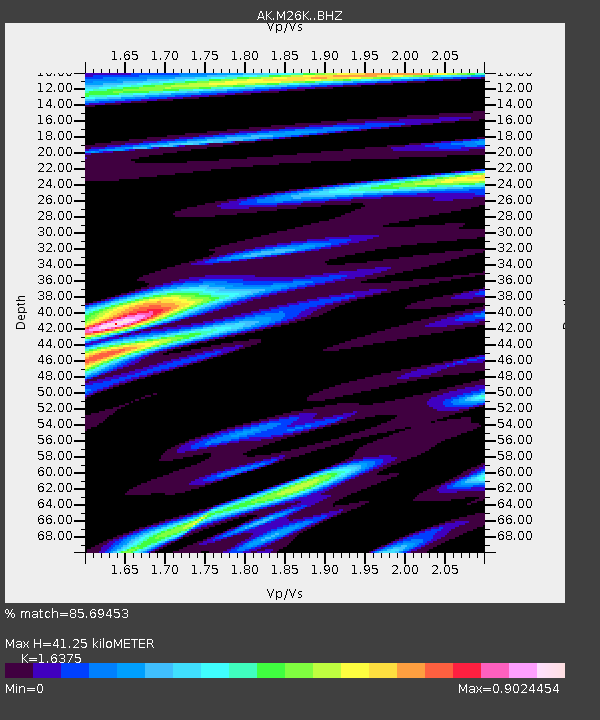
| Estimated Moho Depth: |
41.25 km |
| Estimated Crust Vp/Vs: |
1.64 |
| Assumed Crust Vp: |
6.566 km/s |
| Estimated Crust Vs: |
4.01 km/s |
| Estimated Crust Poisson's Ratio: |
0.20 |
|
| Radial Match: |
85.69453 % |
| Radial Bump: |
400 |
| Transverse Match: |
64.64695 % |
| Transverse Bump: |
400 |
| SOD ConfigId: |
21709731 |
| Insert Time: |
2020-09-08 19:05:25.403 +0000 |
| GWidth: |
2.5 |
| Max Bumps: |
400 |
| Tol: |
0.001 |
|

Signal To Noise
| Channel | StoN | STA | LTA |
| AK:M26K: :BHZ:20200825T19:14:54.460022Z | 13.387091 | 6.7150154E-7 | 5.016038E-8 |
| AK:M26K: :BHN:20200825T19:14:54.460022Z | 3.5120478 | 1.3699139E-7 | 3.9006128E-8 |
| AK:M26K: :BHE:20200825T19:14:54.460022Z | 6.8010178 | 2.9288046E-7 | 4.3064208E-8 |
| Arrivals |
| Ps | 4.1 SECOND |
| PpPs | 16 SECOND |
| PsPs/PpSs | 20 SECOND |


