You are here: Home > Network List > AU - Australian Seismological Centre Stations List
> Station WB2 Warramunga Array, NT > Earthquake Result Viewer
WB2 Warramunga Array, NT - Earthquake Result Viewer
| Earthquake location: |
Southeast Of Honshu, Japan |
| Earthquake latitude/longitude: |
32.8/140.4 |
| Earthquake time(UTC): |
2009/08/12 (224) 22:48:51 GMT |
| Earthquake Depth: |
53 km |
| Earthquake Magnitude: |
6.2 MB, 6.6 MW, 6.6 MW |
| Earthquake Catalog/Contributor: |
WHDF/NEIC |
|
| Network: |
AU Australian Seismological Centre |
| Station: |
WB2 Warramunga Array, NT |
| Lat/Lon: |
19.94 S/134.35 E |
| Elevation: |
425 m |
|
| Distance: |
52.8 deg |
| Az: |
187.145 deg |
| Baz: |
6.392 deg |
| Ray Param: |
0.06640043 |
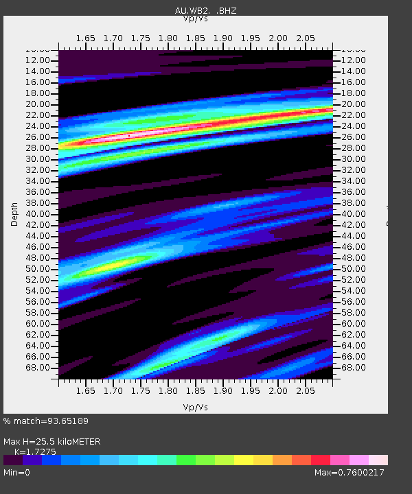
| Estimated Moho Depth: |
25.5 km |
| Estimated Crust Vp/Vs: |
1.73 |
| Assumed Crust Vp: |
6.642 km/s |
| Estimated Crust Vs: |
3.845 km/s |
| Estimated Crust Poisson's Ratio: |
0.25 |
|
| Radial Match: |
93.65189 % |
| Radial Bump: |
356 |
| Transverse Match: |
89.73441 % |
| Transverse Bump: |
400 |
| SOD ConfigId: |
2622 |
| Insert Time: |
2010-03-09 00:30:39.089 +0000 |
| GWidth: |
2.5 |
| Max Bumps: |
400 |
| Tol: |
0.001 |
|

Signal To Noise
| Channel | StoN | STA | LTA |
| AU:WB2: :BHZ:20090812T22:57:30.625017Z | 19.053173 | 6.0256457E-6 | 3.162542E-7 |
| AU:WB2: :BHN:20090812T22:57:30.625017Z | 22.570498 | 3.247416E-6 | 1.438788E-7 |
| AU:WB2: :BHE:20090812T22:57:30.625017Z | 6.845953 | 1.5426559E-6 | 2.2533837E-7 |
| Arrivals |
| Ps | 3.0 SECOND |
| PpPs | 9.9 SECOND |
| PsPs/PpSs | 13 SECOND |


